Zhongar-Aalatau State National Natural Park was established by the Resolution of the Government of RK as of 30 April 2010 №370. Total area of national park was 356,022 ha, of which 200,060 ha were of the forest fund. Besides lands of state forest fund, the lands of the park contain reserve lands with total area of 155961.9 ha.
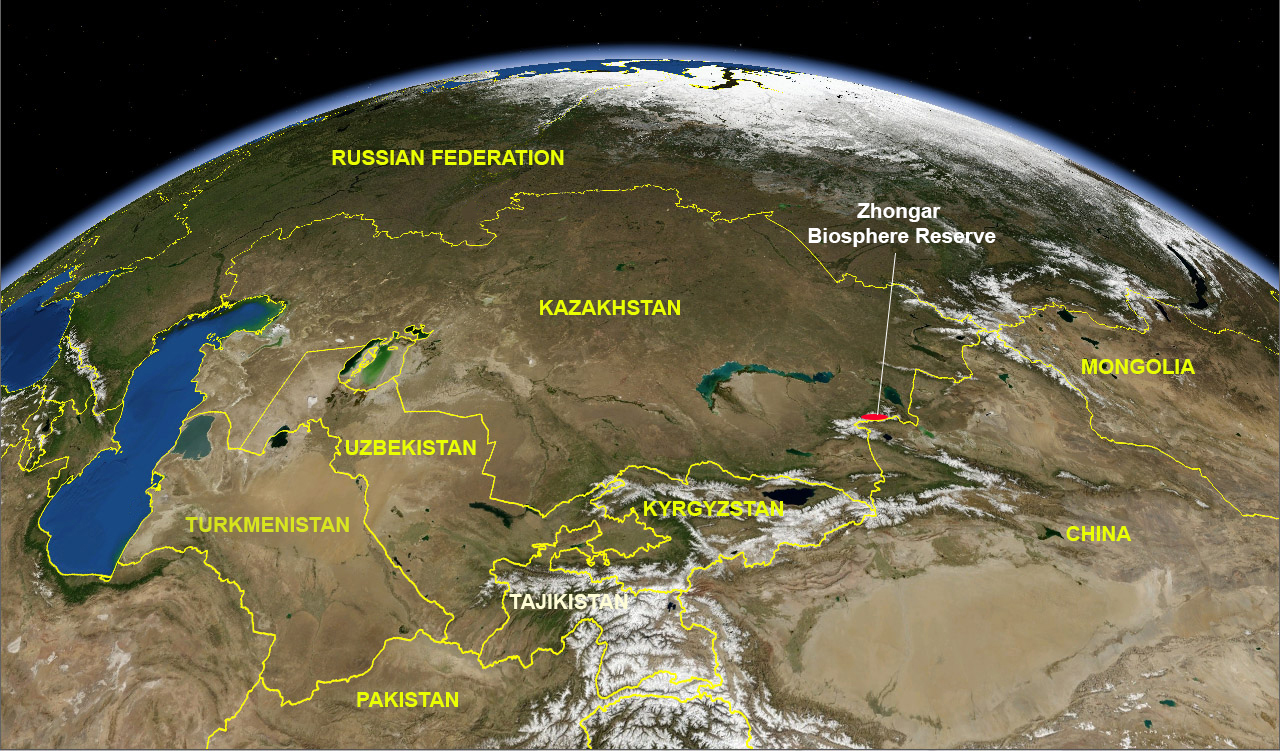
Zhongar biosphere reserve is located on the Northern macroslope of Zhetysu Alatau ridge and embraces all mountain ecosystems characteristic for mountains of Tien Shan and all Central Asia. The mountains of central Eurasia concentrate the main forest resources of the region.
The territory of Zhongar reserve hosts 2,168 plant species, 76 of which are endemic and observed only at that ridge. The territory of the reserve presents not less than 75% of the total number of species inhabiting Zhetysu Alatau, and 73 plant species are listed in the Red Data Book of Kazakhstan. In the present time, the list of higher vascular plants consists of 707 species, 26 of which are in the Red Data Book, and 52 endemic species. There are 54 mammal species, of which 7 species are listed in the Red Data Book of Kazakhstan. Avifauna is represented by 238 species. The complex of nesting birds consists of 130 species. Among nesting birds 11 species are listed in the Red Data Book of Kazakhstan. There are bird species of hunting and economical importance. Many of the birds inhabiting the territory of the national park are rare and insufficiently studied.
It is noteworthy that 1.05% of the total area of Zhongar reserve is occupied by wild fruit plantations of Sieverse's apple, which is the progenitor of all cultural varieties of apples in the world and needs special protection to ensure the conservation and restoration of the unique agrobiodiversity of fruit forests of global importance.
In administrative respect the territory of Zhongar biosphere reserve is located in Sarkand, Aksu and Alakol districts of Almaty region, with total population of 151,000 people. It is necessary to attract the local population in the ecological tourism development in order to raise the social-economic level.
Ecological tourism might provide the high level of life for people on th ebasis of ecologically sustainable nature use.
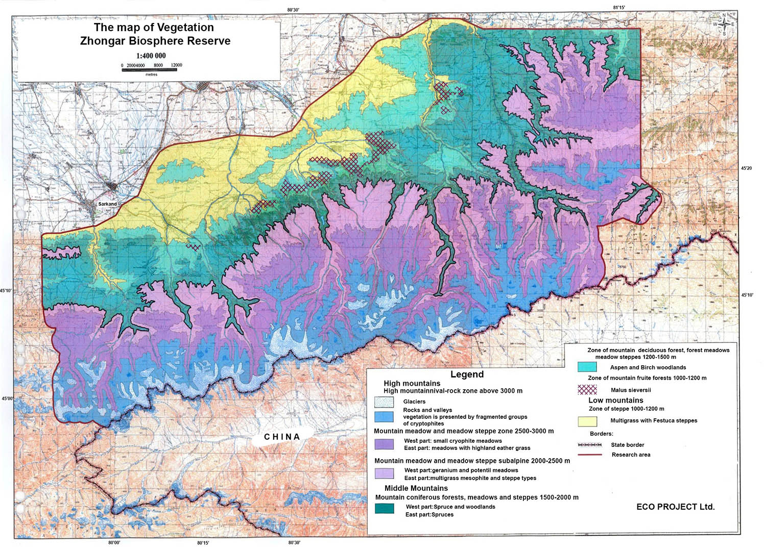
The territory of Zhongar biosphere reserve is located in the mountain and highland part of Zhetysu (Zhongar) Alatau. According to the zoogeographic regioning this territory belongs to Central Asian subregion, Montante-Asian province, Dzhungar- Tien-Shan district, Dzhungar area. Zhetysu Alatau is one of richest in Kazakhstan's regions in the animal species diversity, with only Altai ahead of it. The reserve is located on the Northern macroslope of Zhetysu Alatau ridge and embraces all mountain ecosystems of Tien Shan. The territory of the biosphere reserve contains the following main ecosystem types:
| Высота | Экосистема | Основные виды |
|
3100 (3200) m |
Highland nival – rock zone | Cerastium lithospermifolium, Saxifraga oppositifolia, S. flagellaris, Draba oreades, Sibbaldia tetrandra, Poa relaxa, Waldcheimia tridactylites, Thylacospermum caespitosum, Oxygraphis glacialis, Erysimum altaicum, Melandrium apetalum, Carex nigricans. |
|
2700 (2750)-3100 (3150) m |
Mountain-meadow and meadow steppe alpine zone |
Western part: Dominating species of this formation is Kobresia capilliformis. Characteristic species are Oxygraphis glacialis, Trollius altaicus, Gageae marginata, Tulipa heterophylla, Cerastium tianschanicum, Trisetum altaicum, Polygonum nitens, etc. Eastern part: Kobresia meadows with highland Stipa species (Stipa martinovskyi, S. regeliana), several sedges are present (Carex melanantha, C. parva, C. enervis, C. canescens), Parnassia laxmannii, Pedicularis violascens, Arctous alpina, Eriophorum scheuchzeri. |
| 2200 (2250)-2700 (2750) m | Mountain-meadow and meadow-steppe subalpine zone |
There are juniper thickets (Juniperus pseudosabina). Widely distributed are mesophile medium grass meadows recorded in combination with juniper thicktes. Western part: the meadows are represented mainly by Alcimilla vulgaris, Geranium saxatile, G. albiflorum meadows, sometimes with abundance of cereals, such as Helictotrichon pubescens, Alopecurus pratensis, etc. Eastern part: Polygonum nitens, Alchemilla wichurae, Viola altaica, Aster alpinus, Erigerona zureus, Schultzia crinita, Euphorbia alatavica, Galium verum, Poa attenuata, Phleum phleoides, Festuca rupicola, Leontopodium leontopodioides. are represented mainly by Festuca rupicola phytocoenoses Southern slopes: xerophyte phytocoenoses made of Festuca rupicola, Helictotrichon tianschanicum, Kobresia, Sibbaldia tetrandra. |
| 1700 (1750) - 2200 (2250) m | Zone of mountain spruce forests, forest meadows and meadow steppes |
Picea schrenkiana, Abies sibirica, Rubus saxatilis, Polypodium vulgare, Thalictrum minus, Campanula glomerata, Solidago virgaurea, Polemonium coeruleum. |
| 1350 (1400)-1700 (1750) m | Zone of mountain small deciduous forests, forest meadows, medow steppes and xeropetrophyte steppes | Aspen, shadow-loving forest herbs - Aegopodium podagraria, Birch (Betula procurva) forests, shrubs (Berberis heteropoda, Rosa beggerana), Poa stepposa, Lathyrus humilis, Orobus luteus, Cadonopsis clematidea, Dactilis glomerata, Aegopodium podagraria, Geranium rectum, Bupleurum longifolium, Hypericum hirsutum, Anthriscus sylvestris, etc. |
| 1200 (1250) - 1350 (1400) m | Zone of mountain fruit forests | Apple (Malus sieversii). Grass layer in these forests is mainly high, very developed, Cereals are usually dominating, among them Alopecurus pratensis, Dactylis glomerata,Polygonum songarica, P. alpina, Aconitum septentrionale, Tanacetum boreali, Companula glomerata, Ligusticum discolor, Urtica dioica, Bupleurum longifolium, Veronica parphyriana. Also, steppe species are observed (Pheum phleoides, Festuca ganeschinii, Galium verum) etc. |
| 1000-1200 m |
Steppe zone |
There are motley-grass – Festuca and motley-grass - Stipa zalesskyi (Stipa zalesskyi, Festuca valesiaca, Poa stepposa, Lathyrus pratensis, Thalictrum minus, Galium boreale) steppes, often in combination with Rosa plathyacantha. Areas of Helictotrichon desertorum steppes are also observed.. Southern rocky slopes: petrophytes (Sedum hybridum, Stipa caucasica, Ziziphora bungeana, Patrinia intermedia) and shrubs (Spiraea hypericifolia, Cotoneaste rmelanocarpaи Lonicera microphylla). Stipa steppes: Stipa capillata, (Stipa lessingiana, S. kirghisorum). On the lowest hypsometric levels dominating type is desertified Artemisia – turf cereal steppes (Festuca valesiaca, Artemisia sublessingiana). |
Flora of Zhetysu Alatau includes 112 families, 622 genera and 2,168 species, 76 of which are endemic, recorded only at this ridge. The territory of Zhongar biosphere reserve contains not less than 75% of all species growing in Zhetysu Alatau. To date there are 707 species of higher vascular plants registered for this territory from 413 genera and 78 families, further inventarization works are needed.
Fauna of Zhongar biosphere reserve includes two species of bony fishes, not less than two species of amphibians (maybe 4 species) and 8 species of reptiles, not less than 238 bird species, 54 mammal species. The research of 2015 found 575 insect species of 6 orders, 48 families, 323 genera.
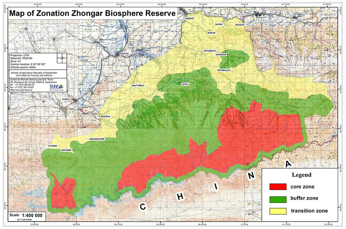
AREA (see map):
Total: (ha).
| Terrestrial | Marine (if applicable) | Total | |
| 7.1 Area of Core Area(s): | 142 927 ha | _______ ha | 142 927 ha |
| 7.2 Area of Buffer Zone(s): | 312 721 ha | _______ ha | 312 721 ha |
| 7.3 Area of Transition Area(s): | 189 900 ha | _______ ha | 189 900 ha |
| TOTAL: | 645 548 ha | _______ ha | 645 548 ha |
Northern ridge of Zhetysu Alatau, where the national park is located, goes down to North in several steps and is abrupt to the adjacent plain by terraced tectonic cliff of 1,500 m in height. Zhetysu Alatau stretches from West to East for 400 km and consists of two main waterdivide ridges – Northern (Zhetysu Alatau itself) and Southern, divided by Koksu – Borotolinskaya depression. The Southern border of the park goes along the protective zone of the state border of Kazakhstan with China. The Western border goes in Ulken Aidausay river valley, Northern border – along the Northern foothill of Zhyldykaragay to Sarkan river, then along the foothills of Markatau mountains to Topolyovka village and along the ground road to Lepsinsk village, then along the foothills to the junction of Tentek and Kipeli rivers through Bezymyannyi Klyuch river valley and along Tentek Vtoroy river valley to the protective zone of state border with China. Here there is a high mountain – Semyonov Tien Shanskiy peak – 4,622 m above sea level.
In 2015 the technical-economic justification of Zhongar-Alatau State National Nature Park was corrected in it functional zoning and general plan of infrastructure development, approved by the Decree of the Committee for forestry and animal world № 181 as of 15.07.2015.
According to this correction, there are the following areas of the functional zone:
- strict nature protection regime– 142,927 ha;
- ecological stabilization – 52,214.2 ha;
- tourist and recreational activity – 81,597.2 ha;
- limited economic activity– 79,283.6 ha;
- protective zone – 99,626 ha.
HUMAN POPULATION OF PROPOSED BIOSPHERE RESERVE:
| Permanently | Seasonally | |
| 10.1 Core Area(s) | NO | No |
| 10.2 Buffer Zone(s) | NO |
About 80 nature protectionists (staff of State Nature Reserve) |
| 10.3 Transition Area(s) |
About 13,000 people |
NO |
| Total: |
About 13,000people |
About 80 nature protectionists (staff of State Nature Reserve) |
Climate is harshly continental, heterogenous, changes considerably with altitude. Characteristic features of the climate of the mountain part – considerable day and season temperature fluctuations, uneven precipitations' distribution throughouth the year, moderate high humidity.
Average annual, monthly and day air temperatures decrease with absolute altitudes increase. This decrease is about 0.6°C in each 100 m of altitude. So, at the foothills of Zhetysu Alatau annual air temperatures are 6-7°C, and at the altitude of 2,500 m they are close to -1°C.
The coldest month is January, day air temperatures are -5-10°C, nights -15-20°C. In the coldest months day temperature may decrease in the foothills down to -40°C, in the mountains – down to -31.6°C, absolute minimum might reach -49°C. The first frost happens in August-September, the last – in May and early June.
Summer in the lower part of the mountains is hot, dry, with clear weather: average monthly temperature of the hottest month (July) in the daytime varies from +22 +24°C to +26 +28°C, at night about +5 +10°C. In the mountains, the summer is cool: day temperature +10 +15°C, maximum +20°C. Stable transition of average air temperatures through 0°C happens in the mountains on April 1 – November 30, through 5°C - April 11 – October 20, through 10°C - April 23 – October 3. In especially hot summer months day temperatures in the foothilss might reach up to +40°C, in the mountains – up to +30.2°C.
Duration of the warm period in the middle mountain zone is 6-7 months, at the altitudes of 3000-3300 m – only 1.5-2 months, and at the altitude of more than 4,000 m there are no long periods with positive temperatures.
Precipitations in Zhetysu Alatau are unevenly distributed: the majority falls on North-Western ridge slopes, the least – on the Eastern, South-Eastern slopes and interhill depressions (Table 4). Most precipitation is observed at the altitudes of about 2,500-3,000 m, from altitude of 3,300 – 3,500 m their amount decreases. In the valleys and depression, located inside the mountain massif, there is less precipitation: 300-400 mm a year. The most moist areas are valleys of the Western part of Zhetysu Alatau, open to the West, where precipitation amount reaches 1,300-1,500 mm.
The most significant rivers are Ulken Aidausai (the tributary of the Aksu River), Sarykan, Baskan, Lepsi, belonging to the basin of Lake Balkhash; Tentek river with tributaries, belonging to the basin of Lake Sasykkol; Tastau River, which belongs to the basin of Lake Alakol.