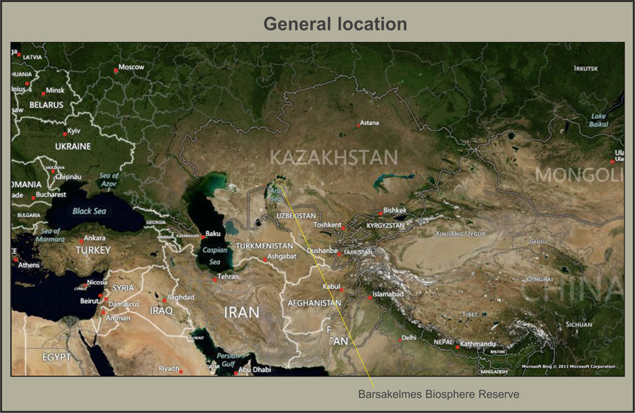
Barsakelmes Biosphere Reserve
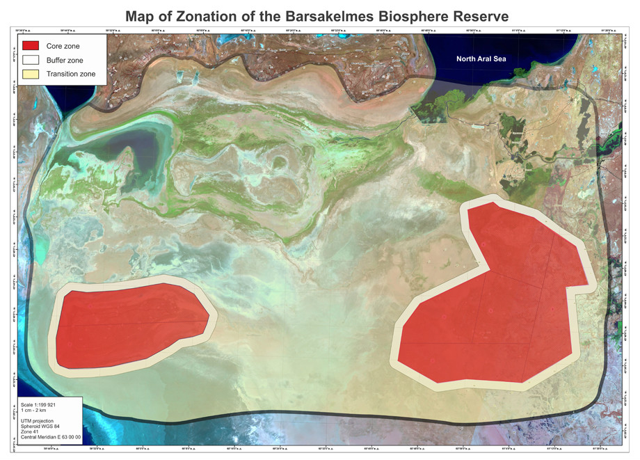
Total area of the territory of Barsakelmes Biosphere Reserve is 407,132 ha. The main core zone (territory of Barsakelmes State Nature Reserve) is 160,826 ha, buffer zone is 46,306.34 ha, development zone – about 200,000 ha.
The main zone of biosphere reserve is strictly protected zone of nature reserve regime of Barsakelmes State Nature Reserve, which represents natural mountain complex of Aral Sea region.
In accordance with Article 39 Chapter 7 of the Law of RK “About specially protected natural territories”: State Nature Reserve shall be a Protected area registered as nature conservation and scientific institution created in order to ensure conservation and research on its territory of natural processes and events, flora and fauna, and separate species of plants and animals, typical and unique ecological systems and restoration thereof. On specially assigned areas, which do not include especially valuable ecological systems and object, it is permitted, in the order stipulated by the authority, to create excursion paths and routes for conducting regulated ecological tourism (Article 42). Barsakelmes State Nature Reserve corresponds with the highest category (A1) of IUCN natural territories. Total area of core zone is 160 826 ha.
The territory of the core zone is located in Aral district of Kyzyzlorda oblast and consists of 2 cluster sites:
- Barsakelmes site includes former territory of nature reserve (16,795 ha) with extension for drainage with total area os 50,884 ha.
- Kaskakulan site as modern habitat of Kulan and large massif of natural Saxaul thickets on drainage with area of 109,942 ha.
The core zone is located in the desert landscape zone of temperate zone, Northern subzone (of Artemisia-Salsola) deserts, Caspian – Turan country, Aral-Syrdarya oblast, Northern-Aral province, Northern-Eastern Aral district.
Northern border of Barsakelmes site starts from the mark located 11.5 km North-Western from North-Western coast of former Barsakelmes island. In 8.1 km goes South-Eastern and stretches for 2.9 km. Then to North-East, in 5.1 km, the border stretches 4 km Eastwards. In 3.1 km South-Eastwards it stretches for 2.4 km and in the same direction another 3.6 km to the Eastern border. The Eastern limit of Barsakelmes site starts from the mark located 7.4 km North-Eastwards from Eastern coast of former Barsakelmes island and goes to the South in 4.7 km, then 7.4 km to South-West. This territory is as far as 6.6 km to South-East from Eastern coast of former Barsakelmes island. Southern border of Barsakelmes site starts from the mark located 6.6 km in South-Eastern direction from Eastern coast of Barsakelmes island and in 14.6 km in South-Western direction, it goes 2.8 km to South-West. Then it stretches 21 km in South-Western direction to a final mark located on the territory of the drained sea bottom in South-Eastern direction, 5.1 km from South-Western coast of former Barsakelmes island. Western limit of Barsakelmes site starts from the mark locate 5.1 km in South-Eastern direction from South-Western coast of Barsakelmes island and in 7.5 km goes in North-Western direction. Then, in 8.2 km to North-East, the border stretches 9.7 km North-Western direction to the Northern border of Barsakelmes site.
Northern limit of Kaskakulan site starts from Tokpan tract and in North-Eastern direction stretches to North-West through Kyzylkak to Sarsenbay site. Then the line of the border changes direction to the East and through Urpek in South-Eastern direction reaches Kosschlyuz. Eastern border of Kaskakulan site starts from Kosshlyuz and in South-Eastern direction stretches to Dandibay Korymys place through Tortkopak stream. Then the border line goes in South-Western direction through nearby territory with Begimana culture monument and in South-Eastern direction reaches Koktobe. Southern border of Kaskakulan site starts from Koktobe and stretches to Orystan kamysy in South-Western direction. Later, the borderline reaches the mark located 21 km North-Western from former Eastern sea coast to the territory of Aral Sea drained bottom to the Eastern borderline. Western border of Kaskakulan starts from the mark located 21 km from the former Aral Sea coast, goes 19 km in North-Eastern direction. This place is located 9.5 km from the former Eastern coast of the Aral Sea. Then the border line reaches Tokpan tract in North-Eastern direction.
Buffer zone of Barsakelmes biosphere reserve comprises the lands of the buffer and protected territories of state reserve. According to Article 43 of the Law of RK «About SPNA»: «buffer zone — the area used for ecologically oriented economic activity and stable reproduction of biological resources». This zone is created to protect specially protected natural territories from unfavourable influences from the outside, with prohibition of any activity that may negatively influence the condition and restoration of the given territory's ecosystems. Lands of the buffer zone are not withdrawn from the main land users, they consist of the lands of agricultural purpose and are administered by agricultural organizations and private bodies. Within the buffer zone of biosphere reserve economic activity in some parts of the protection zone (haymaking, cattle pasture) is carried out by agreement with state authority (Forestry and Hunting Committee of the Ministry of Agriculture of RK) and under the control of the administration of state nature reserve. Eco-educational, tourist, and recreational activities are conducted on the territory of biosphere reserve’s buffer zone, as well as scientific research. The area of the buffer zone is 46 306.34 ha.
Transition zone (collaboration zone) of Barsakelmes biosphere reserve is located on the territory of Aralsk district of Kyzylorda oblast. Total approximate area is 200,000 ha.
Rural population inhabiting delta villages mainly conducts fishing. Fishing villages now are located far from the fishing sites, fishing camps and stations don't have permanent due to instability of hydrological regime of the sea.
There are various forms of economic activities conducted on the territory of biosphere reserve's transition zone without negative influence on the ecological systems' condition:
- forestry;
- traditional land use, including cattle grazing and haymaking, as well as other forms of activities in the frames of long-term conservation of biodiversity;
- tourist and recreational activity;
- use of mineral water, balneologica and climatic resources;
- economic and sport fishing;
- terrestrian and aviational fire-fighting activities to control forest and steppe fires;
- recultivation of disturbed lands;
- rehabilitation of forest and other vegetation associations;
- rehabilitation of environment and wild animals' population;
- use of land plots for tourist sites, nurseries for artificial reproduction and growing of endemic, rare and endangered animal and plant species, as well as construction of service facilities (cordones) for biosphere reserve's staff with giving them land plots.
Most of the lands adjacent to nature reserve are in state possession and are given on the right of constant or temporary land use. They may be divided into the following categories: lands of forest funds; lands of agricultural use; reserve lands; lands for industry, transport, communication, defense and other non-agricultural use. Lands of forest fund are administered by Kyzylorda and Aralsk state institutions for forest and animal world protection, and hunt for large mammals is permitted there. The lands are registered and used by numerous local farmers and production agricultural cooperatives and units, with intensive use of the lands for growing plant cultures, cattle pasture and haymaking.
All three zones are connected and complement each other. The core zone is closed for visits and represents reference areas of regional natural complexes, as well as important genetic reserve of wild flora and fauna species; this zone is a control in long-term monitoring. The buffer zone is also under protective regime, but limited human activity is allowed here (such as tourism, scientific research, educational programs, partial use of natural renewable resources, etc.). Both zones serve for conservation of natural complexes and partially for sustainable development. The transition zone is used for living of local people, development of economy, culture and education. Here there is no strict protection regime of natural complexes, but there are some restrictions on the nature use (ecologically dirty production is prohibited). As a whole, this zoning provides conditions for elimination of the conflict between social-economic development and protection of wild natural complexes and gives an opportunity for stable development of economy and culture.
Two cluster parts of core and buffer zones (former islands Barsakelmes and Kaskakulan) consists of 160,826 ha, the buffer zone – 46,309.34 ha. Barsakelmes part includes former territory of nature reserve (16,975 га) and some part of the dry seabed of the Aral sea with total area of 50,884 ha (reserve’s core zone is 37,725 ha and buffer zone is 13,159 ha). Kaskakulan part occupies 109,942 ha of land (reserve’s core zone is 68,154 ha, and buffer zone is 41,788 ha). These two separate parts of nature reserve are connected by an ecological corridor. Administration of biosphere reserve is located in Aralsk town (36 hours from Almaty by railway). Accessibility of nature reserve territory: driving car to Karateren village (180 km) and further 20 km to West-Northwest (the Syrdarya delta) or 50 km to South-West (Kaskakulan), or 120 km to South-West (former Barsakelmes island). The field road (sand, clay) from Karateren village to Kaskakulan and Barsakelmes part goes through dry seabed, so in spring or autumn it might be hard because of rains and wind storms. The current goal for core and buffer zone is formulated as follows: to provide monitoring observations of succession processes in wild nature ecosystems as well as to protect some wild species of animals and plants against climate change impact.
For organization of partner relations a special Coordinational Council of Barsakelmes Biosphere Reserve was created; its participants include representatives of state nature reserve, nature users, local authorities and public organizations.
Local communities are involved in the development of biosphere reserve's Management Plan and by participating in the Coordinational Council in the integrated reserve's management. Complete management of the core and buffer zone is conducted by the administration of Aksu-Zhabagly state nature reserve, but local NGOs, local communities receive full information on natural complexes of the zones that will be used for education, as well as for tourist routes in the buffer and transition zones, development of scientifically based sustainable nature use, etc.
During UNDP/GEF project “Improving sustainability of PA system in desert ecosystems through promotion of biodiversity-compatible livelihoods in and around PAs” started in 2013 and going on at the present time a complex research of the region is carried out. In the limits of this work the influence of the environment and economical situation on cultural and social life of local people is assessed, new reserve’s management plan is developed, etc.
According to Kazakhstan's legislation, management of economic activity on some parts of biosphere reserve's buffer zone (haymaking, cattle pasture) is carried out by agreement with state authority (Forestry and Hunting Committee under the Ministry of Agriculture of RK) and under control of state nature reserve's administration, all questions and arising problems are settled at the meetings of Coordinational Council of biosphere reserve. During the zonation of buffer zone a consultation with all land users were held.
At the present time there is a Management Plan for core and buffer zones of Barsakelmes Biosphere Reserve, which describes management of the main protected areas of Biosphere Reserve. In the transition zone the land users have their own management plans, which are in accordance with Management Plan of core and buffer zones. So, simple combination of all these plans is in fact Overall Integrated Management Plan of the whole territory of Biosphere Reserve. All controversial issues are discussed at the sessions of Coordinational Council of Biosphere Reserve.
The biosphere reserve is managed through Barsakelmes Biosphere Reserve Coordinational Council created in 2014. Before that the territory of the core and buffer zone was managed by Scientific-Technical Council of the Nature Reserve (until 2014). Coordinational Council is a collegial public body created to introduce policies of effective management and sustainable use of biosphere reserve's resources, alternative activities, resource-conserving and resource-restoring technologies. The Coordinational Council of biosphere reserve consists of representatives of state agencies (territorial agency of forestry and hunting, oblast territorial agency of fishery), state nature reserve, Akimat (department of land resources, agriculture, etc.), local NGOs and land users, and is necessary in providing collaboration and problem-solving opportunities for all stakeholders.
There is a current monitoring of the condition and conservation of natural complexes on the territory of biosphere reserve, and monitoring of rare and threatened species to clarify the condition of the populations, ecological peculiarities of rare plant and animal species, providing a basis for evaluation of the species’ conservation and restoration perspectives. The goal of the monitoring is to obtain regular objective data about the condition of plants and animals on the territory of biosphere reserve, as well as on the condition of their habitat. Based on monitoring data it is necessary to conduct current evaluation of the condition of populations and ecosystems, biosphere reserve’s functioning effectiveness, and development of measures for critical and unfavourable situations’ prevention. According to the Management Plan of Barsakelmes, scientific research on its territory focuses on inventarization and study of the objects of state nature reserve fund, as well as study of natural processes for Nature Chronicles program. This scientific work includes observations of natural phenomena and processes and their study for the «Nature Chronicles» program, flora and vegetation inventarization, research of rare and threatened vertebrate and invertebrate animals, monitoring of biodiversity condition and indicator species' population condition.
For cultural – educational activities in the Reserve there is a department of ecological education. The staff of the Department consists of 4 people - museum chief and 4 instuctors – excursionists. Cultural – educational work is also carried out by staff from Department of Science, Information and Monitoring, and Reserve's Security Service in the area of nature protection legislation. The main work on ecological education is carried out in the form of excursions on ecologicla paths in the protective zone, lectures, articles publication in mass media. There are environmental protection activities such as Parks' March, ecological scouts, etc. In the past such effective methods as slide shows and scientific-popular documentary films were often used, but now the projection equipment is worn out and this kind of activities are not conducted. The goal of Department's work is in raising ecological awareness of local people, their understanding of the key role of the protected territory, importance of unique nature conservation, public support, and raising patriotism and responsibility for the environment, and, as the result, pressure decrease on region's biodiversity from local population. The main activity directions are: work with mass media, publishing activity, museum, ecological excursions, environmental tourism, interactions with teachers and educational bodies. Besides, Department's staff develops posters, leaflets and other agitational materials, and takes part in providing practice for students on the base of nature reserve.
Supported by International Fund for Saving Aral Sea and UNDP/GEF projects the nature reserve’s staff had an opportunity of exchange experience and raise their qualifications in Korgalzhyn Biosphere Reserve, Karatau Nature Reserve (Kazakhstan), Zapovedniki Ecological Center (Moscow, Russia), and at scientific-practical conferences inside Kazakhstan and abroad (Aralsk, Almaty, etc.). In 2009-2011 training seminars were conducted dedicated to preparation of management plan, biodiversity monitoring, state inspectors were trained in drawing up reports, complying with safety operating procedures and fire prevention.
The core zone of Barsakelmes Biosphere Reserve is protected by the state since 10 December 1939 when Barsakelmes state nature reserve was established in the limits of Barsakelmes island, which at that time was almost in the central part of the Aral Sea with area of 180 km2 (18,000 ha) to that date. In the end of last century the process of Aral Sea shrinking became more active, a large area of marine plain around Barsakelmes island was exposed (dried bottom), and the island joined the land part. Dried bottom of Aral Sea became an arena for initial establishment of flora, fauna and unique ecosystems. This territory to the present date is world's only natural «laboratory», where establishment of natural desert ecosystems might be observed at the ititial stages in the conditions of the changing climate. Besides, the necessity to protect already existing unique ecosystems of Northern Turanian deserts, untouched by human economic activity, led to a decision to increase specially protected territory in almost 10 times (160,826 ha) in 2005. In the present time there are 2 cluster parts in Barsakelmes Biosphere Reserve (Barsakelmes and Kaskakulan) with total area of the core zone of 160,826 ha and buffer zone of 46,309.34 ha.
The territory of Barsakelmes Biosphere Reserve belongs to the continental Northern Turanian climatic region of desert zone. According to physical – geographical regioning of Kazakhstan, the territory of nature reserve is included in desert landscape zone of moderate zone, northern subzone of (Artemisia-Salsola) deserts, Caspian-Turanian country, Aral-Syrdarya region, Northern-Aral province, North-Eastern Aral district. The territory of Barsakelmes BR has a high degree of representativeness at regional level.
To date the following species are protected on the territory of Barsakelmes state nature reserve: 298 species of higher plants, 14 of them endemic and 3 listed in the Red Data Book of RoK and in the List of rare and endangered animals and plants of Kazakhstan; approximately 2,000 species of invertebrates, including 3 listed in the Red Data Book; 2 amphibian species; 20 reptile species, which is 46.9% of the total herpetofauna list of the Republic, 14 of them are endemic for Middle Asia and Estern Iran (Turanian herpetologic complex); 30 mammal species or 71.4% of the 42 species inhabiting the desert zone of Kazakhstan. Four of them are listed in the Red Data Book of RoK; and 178 bird species in modern borders of the nature reserve, including 23 listed in the Red Data Book of Kazakhstan.
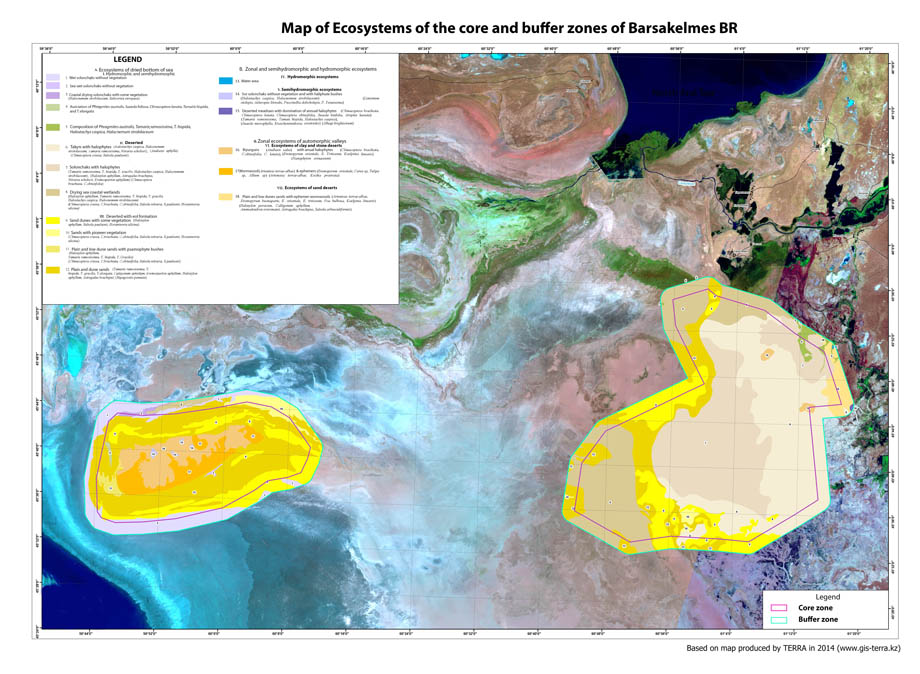
Flora of Barsakelmes Biosphere Reserve consists of 298 higher vascular species, belonging to 50 families and 176 genera. Dominating families are Chenopodiaceae, Compositae, Cruciferae, Poaceae, Polygonaceae, Fabaceae, Boraginaceae, Ranunculaceae, Liliaceae, which constitute 75% of the flora. The largest genera are: Calligonum (16 species), Artemisia (11), Atriplex (11), Astragalus (8), Strigosella (7), Salsola (6), Climacoptera (5). The uniqueness of flora in Barsakelmes Biosphere Reserve might be considered in several aspects. From one side it is flora representativeness as typical for Turanian deserts, reflecting regional botanical diversity. Widely distributed zonal types of vegetation cover include Artemisia terrae-albae, Anabasis salsa, Haloxylon aphyllum etc., which serve as models of undisturbed vegetation. Study of their floristic and phytocenotic structure, as well as functioning, gives comparative material to evaluate factors and direction of desertification processes and ecosystems’ anthropogenic transformation. On the other hand, there are 14 endemics of Kazakhstan (out of 19 on the whole coast) on the rather small territory of biosphere reserve, including Aral neo-endemic – Atriplex pratoviid. There are also rare species listed in the Red Data Book of Kazakhstan (1981; 2008) - Tulipa biflora, T.borszczowii. Forming flora of the dried bottom of the Aral Sea is of global importance, since its study gives a overview of the mechanisms of primary successions and migration routes of bordering floras.
Animal world of Barsakelmes Biosphere Reserve is very diverse and reflects regional fauna. Invertebrates are highly represented, there are more than 2,000 species of only instects belonging to 12 orders: Ephemeroptera, Odonata, Mantodea, Blattaria, Phasmatodea, Dermaptera, Orthoptera, Homoptera, Coleoptera, Lepidoptera, Hymenoptera and Diptera. The most represented group of species is connected with Black Saxaul (Haloxylon aphyllum) – many of them form galls, including genus Stefaniola. Nature reserve’s fauna includes 107 spider species from 61 genera of 18 families. Amphibians are represented by two species – widely distributed European Green Toad and Marsh Frog. There are 12 species of reptiles, 178 bird species, 27 mammal species. Among mammals special attention should be drawn to herbivore species of rodents and ungulates. Two species of jerboas – Small Five-toed Jerboa and Dwarf fat-tailed Jerboa – are native inhabitants of the island. Yellow Ground Squirrel – industrial species – was brought to the island in 1929 and inhabited it successfully. The main protected animal species are ungulates: Saiga Antelope, Asiatic Will Ass (Onager), Goitered Gazelle, which adapted to extreme desert conditions of the island and became the main components of its biocenoses.
In the administrative-economic respect the territory of Barsakelmes Biosphere Reserve is located in Aral region of Kyzylodra oblast. Region was formed in 1929, and its center – Aralsk – attained the status of the city in 1938. Aral region is located in North-Western part of Kyzylorda oblast and occupies the territory of 5,554,574 ha, which consitutes 24.4% of the total of the total area of the oblast. Lands of agricultural use occupy 23.4% of the total territory of the region, settlements – 5%, industrual lands – 2.1% of total territory, lands of the forest funds – 11.5%, water fund – 38%, reserve lands – 19.7%.
There are 21 aul, 2 village and 1 city districts. Total number of settlements is 57. Rural population is 57.9% of total population. The region is populated with 74,700 people with population density of 1.2 person in square km.
The main economic activities are fishery and fish production, salt production and cattle growing. There are huge stocks of food and sodium salt in the region, as well as mirabilite and quartz sand for glass industry. In the present time the following industrial enterprises have their activities in the region : Araltuz JSC, Atameken Rybprom Ltd, Kamkor Lokomotiv Ltd., Kambala Balyk Ltd., Murat M Ltd., Laton Market Ltd., Aral Vagon Ltd. Kamystybasskiy fishing farm grows such fish species as carp, grass carp, and silver carp. The productivity of fish farm is 15 million yearlings. Rural population living in delta villages mainly conducts fishery. Due to drying of the Aral Sea, the infrastructure of fishing industry changed a lot. Fishing villages happened to be located far from fishing sites, fishing stations don’t have constant location due to not stable hydrological regime of the sea. Nevertheless, the increase of the water in Syrdarya starting from 1998 positively influenced the biodiversity of ichthyofauna in Small Aral Sea.
The problem of water supply of the villages is solved by centralized water system, imported drinking and technical water. The problem of water for the cattle is solved by organizing watering places at closely located fresh lakes.
In the limits of Aral region of Kyzylorda oblast forest fund is represented by Saxaul and flood-land forests. Lands of the forest fund of the region occupy 6,372.9 square km. All the transportation in the territory of buffer and transit zones of the biosphere reserve are carried out by cars, including both agricultural machines and personal vehicles. There are 240 km of railroads and car road Samara – Shymkent, the distance to the oblast center is 448 km.
Currently the main scientific – technical support of the biosphere reserve's territory is carried out by the staff of Barsakelmes state nature reserve. The material-technical base was strengthened and numerous training seminars were conducted in the framework of an ongoing project of the Republic of Kazakhstan with GEF and UNDP “Improving sustainability of the systems of specially protected territories in desert ecosystems through promoting biodiversity-compatible alternative livelihoods in and around protected territories”. Administrartion of biosphere reserve is conducting different festivals and competitions, such as «Parks March», Birds’ Day, festivals of children’s art, etc.
The GEF/UNDP Project's equipment was donated (cars, computers and other office appliences, equipment for water quality control, photo cameras, video camera, binoculars, telescopes, GPS, etc.). In 2004-2011 training seminars were conducted dedicated to management plan preparation, biodiversity monitoring, state inspectors were trained in drawing up reports, complying with safety operating procedures and fire prevention, trips for experience exchange were organized for staff members of Barsakelmes state nature reserve to attend Korgalzhyn Biosphere Reserve, Karatau Nature Reserve (Kazakhstan), and to scientific-practical conferences inside Kazakhstan (Almaty, Astana) and abroad (Moscow, Russia). In September 2014 the international scientific practical conference dedicated to 75 anniversary of Barsakelmes Nature Reserve was conducted under support of GEF/UNDP project and International Fund for Saving Aral Sea.
In 2012 Syrdarya Delta was included in the official list of Ramsar Convention; this site is located in the transit zone of the biosphere reserve.
According to botanic-geographic regioning the territory of Barsakelmes Biosphere Reserve belongs to Sahara-Gobi desert zone, Iran-Turanian subzone, North-Turanial province, Western-North-Turanian subprovince, Eastern Aral and Primorskiy districts, Syrdarya and Akkol – Kokaral regions. The territory is located at the junction of nothern and moderate deserts.
Starting from 1960 there is an establishment of new type of lithogenic base in Aral Sea basin in the limits of the dried out part of the sea bottom. This process is connected to the outcrops of marine deposits and creation of new landscape types on their basis – the landscapes of primary marine plains. In the borders of former sea bottom new natural – territorial complexes are formed; their establishment and development considerably depends on the character of bottom deposits' outcrops, underwater elements and relief forms, shoreline dynamics. Former aquatic complexes of sea bottom are under intensive influence of zonal continental processes, mostly aeolian, during the establishment of primary marine plain.
Considerable part of the core and buffer zones of Barsakelmes Biosphere Reserve (plateau of former islands of Barsakelmes and Kaskakulan and lower plain) is zonal (watershed) habitats. The main territory of the islands is occupied by a group of watershed complexes made of three components – phytocenoses of Artemisia terrae albae, Anabasis salsa and Agropyron desertorum formations. Various types of complexes are identified depending on the composition of the elements of the complex. In this group there are six: Artemisia terrae albae – Anabasis salsa; Anabasis salsa – Artemisia terrae-albae; Anabasis salsa – Agropyron desertorum; Artemisia terrae-albae – Anabasis salsa – Agropyron desertorum; Anabasis salsa – Agropyron desertorum – Artemisia terrae-albae; Anabasis salsa – Artemisia terrae-albae – Agropyron desertorum. In many cases these types are complemented by sparse Haloxylon aphyllum found in Artemisia terrae-albae.
Agropyron desertorum - Anabasis salsa - Artemisia terrae-albae is one of the most widely distributed types. It is characterized by domination of phytocenoses of Artemisia terrae-albae formation in 62-79% of the area and 40-50% in occurance. Anabasis salsa occupy 27-35% of the area of the complex and have occurance of 36-46%; Agropyron desertorum occupy 2-5% of the area and have occurance of 12-16%. Thus, secondary elements in this complex have smaller sizes of phytocoenoses.
Agropyron desertorum - Artemisia terrae-albae - Anabasis salsa complex is characterized by reverse relation between Artemisia and Anabasis salsa. The first occupy 42% of the area, the latter – 48%, taking into account that occurance of Anabasis salsa reaches 39%. Artemisia terrae-albae - Agropyron desertorum - Anabasis salsa complex type is found on the plateau slopes, in transition zone to the sands and on other territories with considerably partitioned relief, and sometimes with close deposits of tertiary clays, with Anabasis salsa occupying upt o 65% of the area. The role of Artemisia terrae-albae is decreased, and Agropyron occupies about 20% of the area of the complex and are characterized by rather large sized phytocenoses (occurance 15%). These complexes are quite monotypic and differ by uneven position in the succession processes. The composition of associations that serve as complex elements is most diverse in such kind of three-component complexes. There are overall 14 different associations: Anabasis salsa, Artemisia terrae-albae, Agropyron desertorum, Anabasis salsa + Agropyron desertorum, Artemisia terrae-albae + Haloxylon aphyllum, Artemisia terrae-albae + Anabasis aphylla. Associations of different formations have clear ecological location.
Large areas of low plain are occupied by two-component complex of Artemisia terrae-albae – Anabasis salsa. Artemisia terrae-albae occupies about 60% of the area with occurance of up to 48%. The rest is occupied by Anabasis salsa. A complex of Anabasis salsa – Artemisia terrae-albae is common for Northern part of the plain, especially near takyrs. It is recorded in spots among three-component complexes and occupies up to 40% of the territory in some parts. Two-component complexes are quite monotypic in their associations’ composition, with most often not more than 4 associations (Anabasis salsa only, Artemisia terrae-albae only, Artemisia terrae-albae – Anabasis salsa and Anabasis aphylla - Artemisia terrae-albae).
Overall tendency observed on the territory of the core and buffer zones of Barsakelmes Biosphere Reserve is the following: the increase of the role of Artemisia terrae-albae in watershed conditions (on the plateau it sometimes dominates completely) and their change with Anabasis salsa when the conditions tend to be more intrazonal (slopes, tertiary clays outcrops, takyrs). The character of the complexes changes in accordance to that.
There are five vegetation types identified for the transit zone of the biosphere reserve: desert, meadow, tugay, marsh, and water. Desert vegetation associations are distributed depending on soil-ground conditions. Sand deposits are dominated by Atraphaxideta spinosae, Haloxyloneta aphylli, Ammodendreta bifoli formations. Most of the formations are made of halophile species located in saline soils. Among halophyte formations the most typical are: Artemisieta scopiformidis, Atripliceta pungens, А.pratovi, Climacopterideta aralensis, Aeluropodeta littoralis, etc. Tugay vegetation type is only forming, tree tugay are formed mainly by Saliceta songaricae; characteristic tugay are of two age groups – young and middle-aged. Real tugays might be found only in the lower stream of Syrdarya, before it is parted into channels. Marshy vegetation is formed on the soils of marshy kind: marshy, wetland-marsh, silty-marshy, characterized by Typheta angustifolia, Т.laxmannii, Scirpeta lacustris, S.kasachstanicus, Bolboschoeneta maritimi grass marshes. Aquatic vegetation is formed by hydrophyte plants, for which growing in water is optimal. There are several ecological groups of aquatic plants: hydrophytes, freely floating in the water body; submerged rooting hydrophytes; rooting hydrophytes with floating leaves; hydrophytes freely floating on the surface.
The Barsakelmes BR is extremely important to preserve biodiversity of Aral Sea area. The Aral Sea region is internationally recognized as a priority area for wetland conservation. The Aral Sea lies within one of the most important North-South flyways of Palaearctic migrants with the Central Asian - Indian Flyway and East African Flyway converging over this region. The delta lakes and shorelines provide significant foraging and breeding habitats for large numbers of waterfowl (ducks, geese) and other waterbirds (pelicans, cormorants, herons, plovers, terns, gulls). Thirty bird species are listed to the Red Book. However, avifauna in and around the Aral Sea and in the delta is still spectacular.
Fauna Invertebrates. There are approximately 2095 species from 12 orders of insects in the Aral Sea region: Odonata (13), Mantoptera (3), Blattoptera (2), Phasmoptera (1), Dermaptera (2), Orthoptera (90), Homoptera (520), Heteroptera (125), Coleoptera (731), Lepidoptera (60), Hymenoptera (248), Diptera (300). The most numerous insects are beetles. Information about 18 other orders, inhabiting the Turan deserts, is absent (Kazenas et al., 1998.). Besides species diversity, the level of endemism is an important index of originality. There are 121 Aral-endemic species, which is 5.8% of all known species. This percentage will grow through future research, discovering new local species. For example, the percentage of endemic species of the well-studied Coccinea (Homoptera) and Cecidomiyidae (Diptera) is 35% and 22%, respectively. Biological and ecological features of endemic species remain to be studied. These autochton species are promising subjects for monitoring. Rare and vanishing species are two special categories of regional fauna. Twenty-seven rare species from the Red Data Book of Kazakhstan (2003) inhabit the northern Aral Sea region. More species should be added to the Red Data Book, e. g. Aromia moschata ssp. vetusta Jank. (Coleoptera, Cerambycidae) and Eurythyraea oxyana Sem. (Coleoptera, Buprestidae), which have not been reported in the riverbed forests of the Syr-Darya for twenty years. Current investigations show considerable increase of species diversity of zooplankton in comparison with critical period in the 1980th. 88 taxa of microcrustacea were identified, 55 species and subspecies from them belong to Cladocera, 32 species to Copepoda (2 - Calanoida, 24 – Cyclopoid, 6 -Harpacticoida) and Ostracoda. Fauna of Rotifera consists of 73 species. Also, Bivalvia mollusc larvae were revealed in two waterbodies.
Vertebrates. The vast desert expanses of the North and East Aral Sea region including Aktobe, Kyzylorda and the western part of South Kazakhstan Provinces were inhabited by more than 300 species of vertebrate terrestrial animals. 30% of Kazakhstan mammals were found here, together with 41% of nesting birds and 59% of reptiles, while the local class representation of the desert zone fauna of Kazakhstan were as follows: 79% mammals, 88% reptiles and 95% birds. The most part of these species inhabit the area of Barsakelmes reserve. The waters of the Aral Sea basin were inhabited by more than 40 fish species, among them such unique and endemic ones as Syr-Darya Shovelnose (Pseudoscaphirhynchus fedtschenkoi), Bastard Sturgeon (Acipenser nudiventris), Aral Trout (Salmo trutta aralensis), and Pike Asp (Aspiolucius esocinus); numerous colonies of pelicans (Pelecanus onocrotalus, P. crispus), cormorants (Phalacrocorax carbo, P. pygmaeus), geese, swans, a great number of ducks, herons, gulls, plovers and other bird species were on the islands and shores; wild boar (Sus scrofa) were very abundant in the riparian brushwood along the Syrdarya river; even the Turanian Tiger (Panthera tigris virgata) occurred in the river delta, while adjacent desert sites were inhabited by Saiga (Saiga tatarica) and Persian Gazelle (Gazella subgutturosa); Houbara Bustards (Chlamydotis undulata), Sandgrouse (Pterocles orientalis, P. alchate, Syrrhaptes paradoxus) were also abundant here. Unfortunately, the biodiversity partially has decreased because of the sharp drop in regional water supply and the development of local processes during the second half of the 20th century. Currently in the north half of the Aral Sea 126 bird species are recorded, and 88 species of them nest there while the remainder migrate.
Flora. According to the botanical-geographic regioning the territory of Barsakelmes state reserve is situated in the Iran-Turan subregion of Sahara-Gobi desert region in North Turan province – West-North Turan sub-province, North-Aral (Barsakelmes former island), East-Aral (former islands Kaskakulan and Uzunkair), and Littoral (Aralkum – the dry seafloor) districts. Flora of vascular plants of Barsakelmes and Kaskakulan cluster areas consists of 298 species belonging to 50 families and 176 genera. There are 260 species in Barsakelmes former island and 118 plant species – in the area of Kaskakulan. Species from Chenopodiaceae, Asteraceae, Poaceae, Brassicaceae, Polygonaceae families are prevailing. The most imported genera are: Calligonum (16 species), Artemisia (11), Atriplex (11), Astragalus (8), Strigosella (7), Salsola (6). There are 14 endemics: Artemisia aralensis, A. scopiformis, A. quiqueloba, A. camelorum, Atriplex pratovii, A.pungens, Petrosimonia hirsutissima, Astragalus brachypus, Tulipa borszczovii, Calligonum crispatum, C. palibinii, C. humile, C. spinulosum, Corispermum laxiflorum. The planning cluster area of Barsakelmes Nature reserve “The Syrdarya Delta” consist of 112 vascular species belonging to 35 families and 82 genera. Especially important are the records of plants from the List of Rare and Endangered Plant Species (2006): Kazakhstan cane (Scirpus kasachstanicus) and yellow floatingheart (Nymphoides peltatum). After joining the cluster area The Syrdarya Delta within the boundaries of Barsakelmes Nature reserve 325 species of vascular plants belonging to 60 families, and 191 genera will be protected, among which 18 species (5.5%) are rare and endemic.
Vegetation. The vegetation cover of Barsakelmes former island reflects all botanical diversity of the Aral Sea deserts. Zonal vegetation of plateau – Anabasis salsa – Artemisia terrae-albae complex – is similar to floristic composition and structure of plant communities of North Aral region. Vegetation of a steep Southern coast is analog to the North-Western bays of the Aral Sea with cliffs. Similar species (Amberboa turanica, Artemisia aralensis, Fumaria vaillantii, Ferula canescens) occupy steep slopes and ravines. Psammophytic vegetation of Aral marine terraces has similarity with East Aral region. Penetration of psammophytic species (Calligonum spp., Haloxylon persicum, Ammodendron conollyi, Astragalus brachypus) into the island took place during regressive stages of the Aral Sea through land bridges between the eastern coast of Barsakelmes and mainland (as at present time). Stems of Saxaul found in marine sediments lower then former sea level by 16 m illustrate the existence of regressions in ancient time. Vegetation of Kaskakulan former island is represented by communities of Artemisia with ephemeroids (Artemisia terrae-albae, Tulipa biflora, T.borszczovii, Scorzonera pusilla, Poa bulbosa), Saxaul woodlands (Haloxylon aphyllum, H.persicum) and dwarf semishrub saltwort (Halocnemum strobilaceum). Nearby there is meadow vegetation with Phragmites australis, Saussurea salsa, Atriplex littoralis. Vegetation of the Syrdarya river delta front and surrounding area belonging to 5 types: desert, meadow, tugay, aquatic, and swamp.
In order to solve their social-economic matters the local people are limited in their income-gaining activities to fishery, agriculture and cattle-breeding. Some families exist thanks to pensions and welfare. At the same time new market economy changes their way of thinking: in the recent years people started to be more independent, local population started gaining expertise in market relations. Today more shops are opened in the villages, bus and cargo transportation is organized, many services have opened, including restaurants. It is important to support local population in their activities by development of non-governmental sector, trainings in creation of project proposals and business plans.
Taking into account that there is a potential to develop fish farms on the basis of dried lakes; develop services; there have already been cases of marketing handmade things of leather and wool; and people actively sell milk and milk produce to the city, it is important to develop:
- pond farms to grow pond fish (carp, silver carp, grass carp, etc.);
- gardens;
- facilities for production of national products: blankets, koshma, terme-alash, korpe, etc. and clothes, household objects made of sheep, goat and camel wool;
- services for repairment of shoes and home appliances, hardresser salons;
- facilities to process leather, wool, fish, milk and meat produce;
- in the zone of sustainable economic development support production of local construction materials (adobe bricks, reed mats, etc.) because there is a high demand for it due to mass construction both in district center and villages;
- develop ecological tourism with the main goal to show national tradition of steppe life; visits to ancient city found on the bottom of the Aral Sea, as well as more detailed study of flora and fauna of Syrdarya river delta and conservation of the unique ecosystem.
On a regional scale the experience of development ecological tourism could be successfully used in Kazakhstan and Uzbekistan. Proximity of the reserve to province capital Kyzylorda, as a financial and cultural center with its well developed tourist infrastructure (international airport, railroad and bus stations, hotels, tourist companies, restaurants, etc.) gives tourists a potential possibility to stay in comfortable conditions of the city with possibility of visits of the sightseeing areas. In the future these tourist services will be developed on the territory of biosphere reserve (villages in collaboration zone) in the form of private guest tourism with additional services from local people (hiring and using the boats, horse-riding, fishing, etc.) with realization of local fresh produce and local souvenirs.