
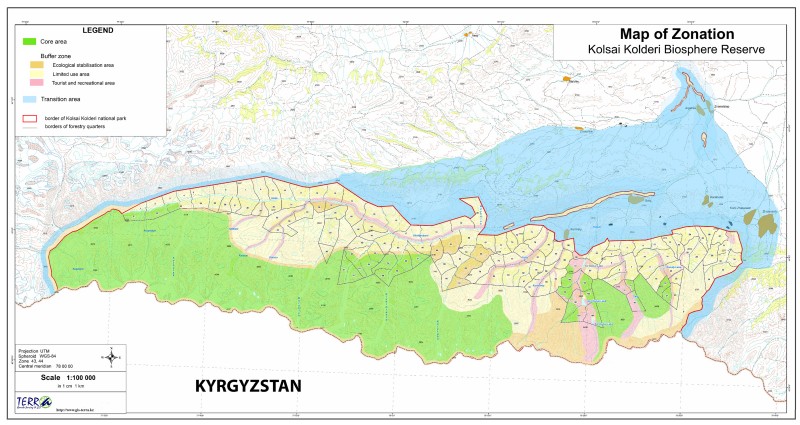
The total area of Kolsay Kolderi BR is 242 085 ha. The core area is 67 962 ha, the buffer zone is 93 083 ha (both the territory of the Kolsay Kolderi state national natural park), and the development zone is about 81 040 ha.
The Kolsai Kolderi Biosphere Reserve is located in the northern part of the Tien Shan mountain system, mainly on the northern slopes of the Kungei Alatau range and partly on the southern side of the Zailiysky Alatau range; both ridges are elongated in the latitudinal direction and are separated by intermountain depressions and basins. In the western part of the reserve, mountain peaks reach altitudes up to 3750-3800 m, and in the eastern part up to 2800-3200 m above sea level. The Kungei Alatau range is characterized by undulating terrain of syrts with chain of rocky peaks rises above. Kolsai Kolderi BR geographically is a part of two administrative districts of Almaty region - Kegen and Talgar district.
The biosphere reserve is organized on the basis of the state national natural park Kolsai Kolderi, which was founded by the Government decree No. 88 of 7 February 2007 on the territory of Kegen and Talgar district of Almaty region, to preserve the natural state of unique mountain landscape with a cascade of lakes, rich flora and fauna, and objects of historical and cultural heritage. The reserve has the status of a legal entity in the form of a state institution.
In the reserve there are well-defined high-altitude vegetation belts in Kungei Alatau: belt of shrub-grass steppes (up to 1600 meters above sea level), spruce-forest belt (from 1600 to 2500-2700 meters above sea level), subalpine belt (from 2700 to 3000 meters above sea level), alpine belt (from 3000 to 3500 meters above sea level), glacial-nival belt (above 3500 meters above sea level).
Within the boundaries of the Kolsai Kolderi biosphere reserve, there are 536 species of vascular plants from 288 genera and 71 families. The reserve is highly representative of the flora of higher plants, as it contains about 75% of the total number of species growing in the Kazakh part of Kungei Alatau. There are 4 strictly endemic species that live only on the Kungei Alatau range: Stipa kungeica, Poa kungeica, Elymus artikaus and Eritrichium kungejense. In addition to them, 2 more narrowly endemic species (Delphinium keminense and Stelleropsis issykkulensis) were found in the vicinity of the reserve, which may also live on the territory of the reserve.
From the group of North Tien Shan endemics living in the Zailiysky Alatau (Trans-Ili Alatau) and Kungei Alatau, 9 species were found in the reserve: Oxytropis chionophylla, Euphorbia prokhanovii, Rhamnus songorica, Scutellaria transiliensis, Erysimum perofskianum, Linaria transiliensis, Scorzonera transiliensis, Hieracium kumbelicum, Euphrasia peduncularis. Two other endemic species of this group (Astragalus karkarensis and Astragalus tauczilikensis) live in the immediate vicinity of the biosphere reserve and their growth within the reserve is quite obvious. In general, taking into account the groups of north-central Tien Shan endemics (19 species) and the group of Tien Shan endemics, 39 endemic species were found in the Kolsai Kolderi biosphere reserve, and the presence of 21 other vascular plant species is quite obvious.
In the northern Tien Shan, including the Kolsai Kolderi BR, the most notable relic is an ancient representative of coniferous and broad-leaved forests of the Paleogene era, the Schrenk’s spruce (Picea schrenkiana), which forms the ancient core of dark coniferous forests along with five other species (Goodyera repens, Orthilia obtusata, Moneses uniflora, Pyrola minor, Pyrola rotundifolia). In general, 34 species belong to the relict plants that live on the territory of Kolsai Kolderi BR. All of them need special protection and further study. Some of these species belong to the category of particularly rare, listed in the Red Data Book of Kazakhstan (12 species).
The Kolsai Kolderi BR has about 226 species of vertebrates, or 21% of the vertebrate fauna of Kazakhstan. Out of this number, 7 species of mammals and 12 species of birds are included in the Red Data Book of the Republic of Kazakhstan, which is 17% of the number of red book species. The list of fauna species of the biosphere reserve is given in this website separately.
On the territory of the Kolsai Kolderi BR, within the heights of 1800-3500 m above sea level, there are unique mountain landscapes with a cascade of lakes, rich animal and plant life, including rare and endangered species of flora and fauna. Some parts of the wild untouched natural environment (about a third of the territory) have been preserved, which are assigned to the core area. The value of the biosphere reserve for the conservation function is as follows:
● glaciers and snow cover in the highlands are a stabilizing factor for maintaining the water balance and preserving the regional microclimate;
● mountain and steppe ecosystems are the habitat of endemic, rare and endangered species of animals and plants (especially natural spruce forests and juniper forests);
● spruce forests and juniper woodlands have a great soil protection property;
● there are 40 species of food and wild fruit plants and 29 species of medicinal plants;
● there are objects of historical and cultural heritage: petroglyphs of Tanbaly Tas, Ashyl Togay, Taskala, a Wooden log house of Aden one of the Kazakh rulers, the ancient structure of the Kazakh settlement, the village of Baryskhan.

According to the latest botanical-geographical zoning the territory of BR Kolsai Kolderi refers to the Zailiyskiy subprovince, Zailiyskiy-North Zhongarian province of the Iranian-Turanian subregion. The reserve is located in the central part of the northern slope of the ridge, bounded by the course of the Kurmety river to the West and the Kensu river to the East.
The territory of the Kolsai Kolderi BR is an integral part of the Ile-Balkhash basin, and includes characteristic types and subtypes of ecosystems, according to their geographical location, orographic features and altitude characteristics. The following main types of ecosystems can be distinguished on the territory of the biosphere reserve:
I. Mountain ecosystems
Ecosystems of mountain steppes combine different types of steppes, forming different subfields in the foothills, lowlands, midlands and highlands in the range of heights of 400-2400 m above sea level. They are common to the slopes of the southern exposure and the dominance of communities of xerophytic turf grasses, the participation of xerophytic grasses and shrubs. Steppe communities of different zones differ in the substitutive dominance of grasses and multigrasses and the presence of characteristic groups of species. The following edaphic variants of mountain-steppe ecosystems are distinguished, which characterize the corresponding sub-zones: mountain grass-cereal and shrub steppes on mountain chernozems, mountain turf-slag dry steppes on mountain chestnut soils, mountain desolate steppes on light chestnut soils, and large-grass-ephemeroid-grass-sagebrush steppes on ordinary serozems.
The following mountain-steppe ecosystems can be found within the reserve:
High-altitude cryophytic ecosystems are confined to the southern slopes of the mountains in the altitude range of 2200-2900 m. Cryophytic steppes are formed by communities of microthermic small-grain cereals from the genera fescue (Festuca), bluegrass (Poa), feather grass (Stipa), and barley (Hordeum) and ovsets (Нelictotrichon) reoperating with an abundance of cryopetrophytic variegated grasses and the participation of juniper (Juniperus species).
Mid-mountain steppe ecosystems (1600-2400 m) are represented by real and petrophytic grass-turf-grass steppes dominated by Festuca valesiaca, various types of feather grass (Stipa zalesskii, Stipa capillata, S. lessingiana, S.kirghisorum), Koeleria cristata, as well as Нelictotrichon songorica, often with bushes Rosa, Spiraea, Cotoneaster, Atraphaxis etc., various types of xerophytic grasses (Hedysarum, Galium, Medicago, Salvia, Origanum), as well as meadow steppes, which are composed of both steppe and meadow types of cereals and various grasses (Festuca valesiaca, Stipa zalesskii, Poa stepposa, Phleum phleoides, Dactylis glomerata, Poa pratensis, P.angustifolia, types of various grasses from genera Thalictrum, Hieraceum, Senecio, Aconitum, Delfinium). Soils are mountain chestnut and mountain chernozem.
Low-mountain dry-steppe within the heights of 1400-1700 m. Feather grasses predominate in the composition of communities (Stipa capillata, S. lessingiana, S. kirghisorum) and Festuca valesiaca, drought-resistant grasses, as well as mountain types of sagebrush (Artemisia tianschanica), Ajania fastigiata and bushes Spiraea, Atraphaxis, Rosa, Caragana. These are places where many rare ornamental species of early spring flora grow - tulips, irises. The soil is chestnut and light-brown mountain.
Shrub ecosystems – they are typical for foothills, low mountains, and small hills and form a special belt in the mountains (1800-1850 m above sea level). They are formed by different types of shrubs of rosehip, honeysuckle, meadowsweet, dogwood, etc., sometimes with the participation of apple, apricot and Semenov’s maple. Barberry trees (Berberis species) and raspberry bushes (Rubus) are widely distributed) and currants. Shrubby thickets are usually found in combination with steppe and meadow ecosystems, and also form undergrowth and thickets in clearings in forests. Juniper thickets predominate in the upper zones of the mountains (Juniperus pseudosabina, J. sabina).
Mountain forest ecosystems there are two types:
Coniferous forests, dark-coniferous spruce on mountain-forest dark-colored soils. A special feature of these forests is the dominance of an endemic species in the forest stand – Schrenk’s spruce (Picea schrenkiana). A special feature of these forests is the dominance of an endemic species in the tree stand – Sсhrenk’s spruce. Artificial pine stands are often found. Coniferous forests are sometimes characterized by an admixture of hardwoods (aspen, birch) and shrubby undergrowth (rowan, willow, honeysuckle, rosehip, euonymus). They form a wide belt at an altitude of 1400-2800 m above sea level.
Deciduous forests on mountain-forest dark-colored soils, in which the tree layer is formed by birch (Betula tijanschanica, B. pendula), aspen (Populus tremula), sometimes with the participation of spruce. Deciduous forests both full-bodied and rare-coniferous have a well-defined shrubby undergrowth (species of honeysuckle, dogwood, birch, rowan, etc.). They form a sub-belt at an altitude of 1100 to 1900 m above sea level and are found fragmentally in the spruce belt, here they are secondary and usually formed on the burning.
Mountain meadow ecosystems are found in all zones, mainly on the Northern slopes, in gorges and logs, and are represented by the following subtypes:
High-altitude alpine and subalpine are meadows in belts at altitudes from 2200 to 3800 m above sea level. They are distinguished by the richness of the flora. Cryophytic meadows are mainly represented by cobresia and sedge-grass-grass communities on sod-meadow coarse-humus soils. These types of ecosystems are virtually unaffected by economic activity and still have a background state.
Mid-mountain and low-mountain real meadows (600-2200 м) - they are found in combination with forest and steppe ecosystems. They are characterized by a rich floral composition and the dominance of mesophytic cereals (Poa, Dactylus glomerata) and large grasses (Inula helenium, Aconitum, Hyeraclea, Geranium).
The glacial-Nival and subnival zones of the ecosystem are located in the alpine belt of mountains at an altitude of more than 3800 m above sea level. they are formed by glaciers, moraines, eternal snows and are devoid of soil and vegetation cover. Sometimes groups of cryophytic pads are found on gravelly, fine-grained areas.
II. Intrasonal (hydromorphic and semihydromorphic) ecosystems
This is a special type of ecosystem that is typical in the reserve for river valleys, lake coasts, spring meadows, and areas of underground and ground water wedging (saz). Their spatial distribution also follows the laws of the altitude zone. There are 3 subtypes of hydromorphic ecosystems: meadows, grass swamps, and floodplain forests (tree and shrub thickets). Hydromorphic ecosystems of each high-altitude mountain belt have their own specific set of dominant species, but they have similar structure and functional features, as well as the same type of response to natural and anthropogenic factors. In comparison with zonal types, they are often distinguished by a large floral and phytocenotic diversity.
Meadow ecosystems in the reserve are formed in floodplains of rivers on alluvial soils of the meadow series and combine the types of real psychromesophytic (mountain) meadows. The vegetation cover is dominated by mixed and monodominant communities of mesophytic grasses and various grasses. The mountain floodplains are dominated by sedge-grass-mixed grasses (Carex, Poa pratensis, Alopecurus pratensis, Veronica longifolia, Mentha arvensis).
Grass swamp ecosystems are formed on the soils of the swamp series in conditions of excessive moisture and are associated with negative terrain positions. They are also typical for areas of ground water wedging (saz). In the valleys of mountain rivers, they are dominated by various types of sedge.
Floodplain-forest ecosystems are formed in the riverbed of meadow-forest soils. In the valley of the Shilik river the riparian forests in the belt of low mountains and foothills, buckthorn-willow-poplar with Russian Olive predominate.
III. Water and coastal water ecosystems
Water ecosystems include rivers, lakes, reservoirs, ponds, and other aquatic complexes. On the territory of BR there are many rivers and various reservoirs, as well as unique mountain lakes-Kolsai and others.
IV. Agroecosystems. Within the BR, they occupy limited areas, represented by vegetable gardens and gardens at cordons, nurseries of forest crops.
V. Urboecosystem. Ecosystems of localities (absent in the core zone and buffer zone). Existing infrastructure facilities are small in size, including localities in the transit zone, as well as cordons and a recreation area on the Lower Kolsay lake in the buffer zone of the reserve. Small ecosystems of this type are located in the transit zone of the reserve (Saty village and others).
BR Kolsai Kolderi is geographically part of two districts of Almaty region - Talgar and Kegen. Talgar district includes some part of the territory on the left bank of the Shilik river. Moreover, there are no settlements in the Talgar district adjacent to the reserve territory, and the small population is mainly engaged in cattle breeding. The entire existing infrastructure of the reserve is located in the Kegen district, which includes all localities close to the borders of the reserve, whose residents need to use its territory. All employees of the biosphere reserve are also residents of these settlements.
Geographically, Kegen district is divided into 12 rural districts, where 32,400 people live. About 8 thousand people live in the transition zone of the biosphere reserve, who use public and private agricultural land. As of 01.01.2018, there are 781 individual entrepreneurs working under patents in the district. 1521 farms were registered.
In agricultural production, meat and dairy production is predominant. Currently, crop production accounts for 20-25% of the total value of gross agricultural output in the district, and livestock production accounts for 75-80%. Grain crops, mainly wheat, potatoes, and vegetables are grown on the arable land of the district. There is no major industrial production in the area.
Migration had a significant impact on the formation of the region's population. After the collapse of the Soviet Union, the population declined. The process of migration from the village to the city has begun. Especially attracts young people and rural residents to the nearby southern capital – Almaty. The main reason for migration is unemployment. A close - located metropolitan area leads to an active outflow of the working-age population for employment and higher earnings.
The main activity of the local population living in the immediate vicinity of the biosphere reserve is animal husbandry and agricultural production. Grain crops (wheat, barley) and fodder crops (clover, alfalfa) are grown on bogarny arable land. The farms contain sheep, cattle, goats, horses and poultry.
The main activity of the local population living in the transit area and in the immediate vicinity of the biosphere reserve is animal husbandry and crop production. Grain crops (wheat, oats), fodder crops (clover, alfalfa), and potatoes are grown on bogarny arable land. The farms contain sheep, cattle, goats, horses and poultry. Houses are heated with coal, firewood, dung. Small retail outlets are located in each locality, and large bazaars are located in the centers of rural districts and the district center.
All transportation is carried out by road on the Almaty – Narynkol highway through the Kegen district center. From this highway there is a branch to the village of Zhalanash and then, through Karabulak, Saty to the village of Kurmety. The road is 120 km long and paved. The reserve has 171 km of on-farm roads and 113 km of trails. On-farm roads are used for fire prevention, reforestation, and transportation of tourists and vacationers. Mountain trails serve as a walking and horse transport for local residents and tourists. Communications companies include the district telecommunications hub and the postal service.
The territory of the biosphere reserve demonstrates its contrasting natural conditions, from the steppe foothills to the ice peaks of the alpine belt. There are plains, canyons, mountain ranges, stormy rivers, and beautiful lakes framed by the wonderful beauty of coniferous and deciduous forests. The buffer and transit zone of the reserve has excellent opportunities for the development of tourism, recreation and entertainment. The presence of rich natural resources, good natural and climatic conditions make the region promising in terms of development primarily of recreation and eco-tourism. The possibility of amateur hunting and fishing can also attract additional visitors. In addition to the biosphere reserve, Kegen district also has the Khan-Tengri mountaineering camp and the upper part of the Charyn canyon, which also contribute to the development of tourism.
To date, 5 routes have been developed, but in the future it is planned to open new walking and horse routes, equip and launch them. Tourist routes # 1 "Saty village – Kaindy lake", # 2 "Saty village - Saty pass", # 3 "lower Kolsay lake – Sarybulak pass", # 4 "Kurmety village – Middle Kolsay lake", # 5 "Kurmety village - mount Kyzemshek". Trail improvement includes trail marking, construction of anti-erosion descents, equipment of bivouac and observation platforms, construction of crossings, information signs. On the road-tropical network, route signs, distances, names of recreation places, etc. are installed in the necessary places. Employees of the Department of environmental education and tourism of the biosphere reserve, working together with the population of localities in the transition area, provide additional services to visitors to the biosphere reserve. On the part of the local population it is the provision of guest houses, the provision of horses, the sale of national dishes and dairy products. In the village of Saty there are 80-85 guest houses that accept and provide services to foreign and domestic tourists.
The main scientific and technical support on the territory of the BR is provided by the entire staff of the Kolsai Kolderi biosphere reserve, who have been trained in various courses within the framework of state programs for the development of the national protected areas system. Training seminars were held on the preparation of a management plan, monitoring of biodiversity, compliance with safety and fire extinguishing regulations, as well as business trips to exchange experience in the Aksu-Zhabagly biosphere reserve, Altyn-Emel, Karatau, etc. Annually by the administration BR Kolsai Kolderi various festivals and competitions (March for parks, a celebration of birds, children's talent competitions, etc.) are organised.
The core area of the biosphere reserve is a strictly protected area of the Kolsai Kolderi state national nature park, which preserves the most valuable natural mountain ecosystems of the Northern Tien Shan. The law of the Republic of Kazakhstan "on specially protected natural territories" in article 44 of Chapter 8 gives a clear definition of the national natural park: "state national nature Park — a specially protected natural territory with the status of environmental and scientific institutions for the preservation of biological and landscape diversity, conservation, environmental and educational, scientific, tourist and recreational purposes unique natural complexes and objects of state natural-reserved fund, which have special ecological, scientific, cultural, historical and recreational value". In accordance with article 45 paragraph 2 of the same Law: "the area of the protected mode prevents any economic activities and recreational use of the state national natural Park and set protected mode of protection appropriate to the type of regime of state nature reserve".
Kolsay Kolderi state national natural park corresponds to the highest category (A1) of natural territories of the International Union for Conservation of Nature. The core area of the Kolsai Kolderi biosphere reserve is 67 962 ha, which consists of eight large and two relatively small areas.
The buffer zone of the biosphere reserve according to article 45 (paragraph 1) Of the law of the Republic of Kazakhstan" on protected areas " are 3 zones of the state national nature park: a) environmental stabilization; b) tourist and recreational activities; C) limited economic activities, as well as a specially designated protected area of the reserve, which covers a two-kilometer strip around the perimeter of the national park.
According to article 45 (paragraphs 3, 4, 5 and 6), as well as article 46-48 of this Law:
"3. in the zone of ecological stabilization, a protected protection regime is established with the prohibition of economic and recreational activities, with the exception of regulated ecotourism and measures to restore disturbed natural complexes and objects of the state nature reserve fund.
4. the zone of tourist and recreational activities is divided into sections of regulated short-term recreation and long-term recreation of visitors to the state national natural Park. In the area of tourist and recreational activities is set custom mode, ensuring the preservation of natural complexes and objects of state natural-reserved Fund on the territory of which allowed regulated tourist and recreational use (except for hunting), including organization of tourist routes, paths, device camping sites and lookouts, beaches, boating, rental, water transport and beach equipment taking into account the norms of recreational load.
5. in the zone of limited economic activity, administrative and economic objects are located, economic activities necessary for the protection and functioning of the state national natural Park are carried out, services for its visitors, including the organization of amateur (sports) hunting and fishing, construction and operation of recreational centers, hotels, campsites, museums and other tourist facilities are carried out.
6. all areas of the state national natural Park are protected, protected and rehabilitated in accordance with the management plan.”
A protected area is created to protect against adverse external influences around specially protected natural areas, with the prohibition of any activity within these zones that negatively affects the state and restoration of the ecosystems of these territories.
On the territory of the buffer zone of the BR there are lands that have not been withdrawn from the main land users, they consist of agricultural land and are managed by agricultural organizations and individuals. Management of economic activities in certain areas of the protected zone (haymaking, grazing) is carried out in coordination with the state Authorized body (Committee of Forestry and Wildlife Ministry of Ecology, Geology and Natural Resources RK) and under the control of the administration of the state natural national park.
The reserve's buffer zone covers 93 083 ha, which includes an environmental stabilization zone (16 715 ha), a tourist and recreational activity zone (9 451 ha), a restricted economic activity zone (66 917 ha).
Transition area (development/cooperation zone) Kolsay Kolderi BR located on the land territory of the two districts of Almaty region Talgar and Kegen. The total land area of the transition zone is approximately 81 040 ha.
Due to their climatic conditions, the most favorable living conditions for people are located in the foothill zones at altitudes up to 1000 m above sea level. The main concentration of settlements is confined to the foothill areas at the outlet of the main rivers and streams from the mountain gorges to the plain. Thus, on the territory to the North-East of the buffer zone of the reserve there are few settlements. Most of the land adjacent to the reserve is state-owned and granted permanent or temporary land use. The land used in the transit zone, which is assigned to local farmers and agricultural production cooperatives and associations, is used for growing crops, grazing livestock, and haymaking.
All three zones are connected and complement each other. The core zone is closed to the public and represents reference areas of regional natural complexes, as well as an inviolable genetic reserve of wild species of flora and fauna. This zone is a control for long-term monitoring.
The buffer zone is also under a protective regime, but limited economic activities are carried out here taking into account the preservation and restoration of objects of the state nature reserve Fund and according to the relevant permits of the state bodies that manage them. Tourist and recreational activities in this zone are carried out directly by the state national natural park or by individuals and legal entities if they have a license for tour operator activities. Individuals and legal entities are still obliged to bring the site into a state that ensures the safety of objects of the state nature reserve Fund, and comply with the requirements for environmental protection. Both zones perform the function of preserving natural complexes and partly the function of sustainable development.
In the transition area, the main types of traditional economic activities of land users that ensure the sustainable use of natural resources are allowed, but the types of natural use and economic activities that negatively affect environmental systems are prohibited or restricted. Restrictions on the economic activity of land owners and land users in the protected area of the state national natural park are established by decisions of local Executive bodies of regions, cities of republican significance, and the capital in accordance with this Law. This area is used for the implementation of the life of the local population, the development of the economy, culture and education, and provides the function of sustainable development of the territory.
In general, the existing zoning provides for overcoming the conflict between socio-economic development and the protection of wild natural complexes and provides an opportunity for sustainable economic and cultural development.
To attract the appropriate range of partners, the Coordination Council of Kolsay Kolderi BR was created, which includes representatives of the state nature reserve, nature users, local authorities and public organizations.
Local communities were involved in the development of the BR Management Plan and through participation in the Coordination Council in the integrated reserve management. Control of the core area and buffer zone relates to the state national natural park Kolsai Kolderi, but local non-governmental organizations, local communities receive the full information about the nature of these areas, which is further used for educational purposes, as well as the development of tourist routes in the buffer and transition zones, the development of science-based environmental management etc.
As part of the preparation of the new Management Plan for 2019 - 2023, comprehensive studies of the region were conducted. In the course of which, the socio-economic development of communities was revealed, the impact of the natural environment and economic situation on the cultural and social life of the local population was assessed, a management plan for the reserve was developed, etc. Socio-economic conditions and historical and cultural features of the region are given in the first part of the reserve management plan.
