The Markakol basin is a unique geobiosystem of the Southern Altai. It unites into a single whole the water area of the second largest lake in Eastern Kazakhstan with its ichthyofauna and ornithofauna, benthos and plankton, flora of hydro-and hygrophytes, representatives of terrestrial flora and fauna living on the ridges surrounding the lake, diverse in origin, distribution and ecology. The multifactorial impact of a number of climatic and orographic factors on the flora and fauna of the Markakol basin and adjacent areas led to the formation of a unique complex of wildlife. Remoteness, inaccessibility, low population, harsh natural and climatic conditions of both protected areas contributed to the preservation of almost pristine reference ecosystems, which are not represented or protected anywhere else in Kazakhstan and in the world.
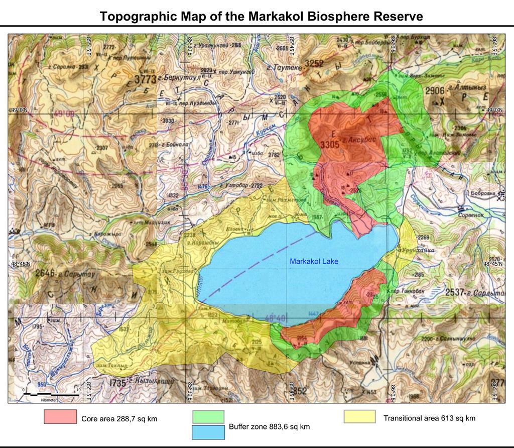
The total area of the Markakol Biosphere Reserve is 164 408. 5 hectares, of which 46 028 hectares account for the water surface of Lake Markakol. The core area (the territory of the West Altai State Nature Reserve) accounts for 28 870 ha, the buffer zone is 74 238.5 ha, the transition area is about 61 300 ha.
The core area of the biosphere reserve is two cluster land plots belonging to the zone of the protected regime of the Markakol State Nature Reserve:
1) The Northern mountain and forest protected area (the border of the site runs from the state institution "Markakolsky forestry" to the quarterly pillar No. 6-7, then from the north-northwest along the lands of the State land reserve and along the coast of Lake Markakol including the forest quarter 25)
2) The Southern mountain and forest reserve area (the border runs along the south-eastern coast of Lake Markakol and further to the south-west along the border with the state institution "Markakol Forestry", and further along the border with the lands of the State Land Reserve)
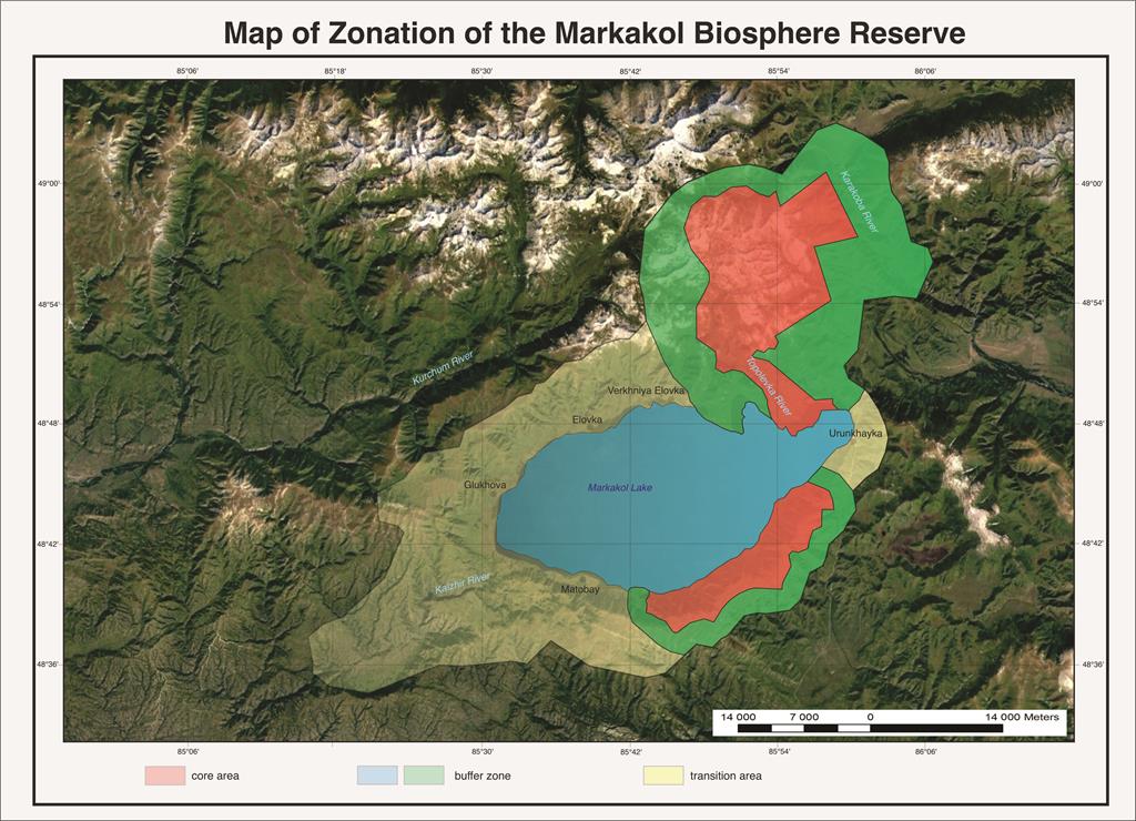
The buffer zone of the Markakol Biosphere Reserve is the territories:
1) two ground sections of the protected area of the reserve, which encircle 2 cluster sections of the core area of the biosphere reserve;
2) the entire water surface of Lake Markakol, which belongs to the zone of the strong protected regime of the state natural reserve Markakol;
Lake Markakol, which according to national legislation belongs to the zone of the protected regime of the state strict nature reserve Markakol, is referred here to the buffer zone of the UNESCO biosphere Reserve in connection with the application of Article 43-1 of the Law of the Republic of Kazakhstan and more stringent UNESCO requirements for the protection of natural ecosystems in the core zone of the biosphere reserve.
According to Article 43-1, Peculiarities of the protection regime of certain state nature reserves, Chapter 7 of the Law of the Republic of Kazakhstan on Specially Protected Natural Territories:
"1. On the territory of the Markakol State Strict Nature Reserve, it is allowed:
1) amateur (sports) fishing for the needs of the local population living in the protected area of this reserve, on specially designated areas on the basis of a biological justification in the presence of a positive conclusion of the state environmental expertise in accordance with the legislation of the Republic of Kazakhstan;
2) regulation of the number of animals on the basis of biological justification in the presence of a positive conclusion of the state environmental expertise."
According to Article 43 of the Law of the Republic of Kazakhstan "On Protected Areas", protected zones are created to protect against adverse external influences around specially protected natural territories, with the prohibition of any activity within these zones that negatively affects the state and restoration of the ecosystems of these territories. On the territory of the BR, the buffer zone lands are not withdrawn from the main land users, they consist of agricultural land and are managed by agricultural organizations and individuals. Economic activity in certain areas of the protected zone (haymaking, cattle grazing) is carried out in coordination with the state Authorized body (the Committee of Forestry and Wildlife of the Republic of Kazakhstan) and under the control of the administration of the state nature reserve. On the territory of the buffer zone of the BR, events in the field of environmental education, leisure, ecotourism are held, as well as scientific research is conducted.
The transition area of the Markakol Biosphere Reserve is a large part of the protected zone of the Markakol State Nature Reserve including the Kaldzhir technical section, the border of this technical section includes the upper course of the Kaldzhir River to the confluence of the tributary of the Shukyrkolzhir River. The total land area of the transition zone is 61 300 hectares.
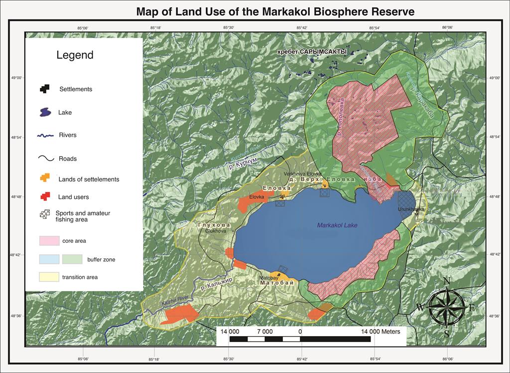
Due to its climatic conditions, the most favorable living conditions for people are located in the coastal territory of Lake Markakol. As a result, the main concentration of settlements is confined to the coast of Lake Markakol (the village of Urunhaika, the villages of Matobai, Glukhova, Elovka). On the lands of the transit zone assigned to various local farmers and agricultural production cooperatives, amateur hunting and fishing, grazing of livestock and cultivation of agricultural plants are carried out.
All three zones are connected and complement each other. the core zarea is closed to visitors and represents reference areas of regional natural complexes, as well as an inviolable genetic reserve of wild species of flora and fauna, this zone is a control one during long-term monitoring. The buffer zone is also under a protective regime, but limited human activities are allowed here (tourism, scientific research, educational programs, partial use of natural renewable resources, etc.). Both zones perform the function of preserving natural complexes and partly the function of sustainable development. The transition area is used for the implementation of the life activities of the local population, the development of the economy, culture and education. There is no strict regime for the protection of natural complexes, but there are restrictions on the use of natural resources (environmentally dirty production is prohibited). In general, such zoning provides for overcoming the conflict between socio-economic development and the protection of wild natural complexes and provides an opportunity for sustainable economic and cultural development.
To attract the appropriate range of partners, the Coordinating Council of the Markakol Biosphere Reserve has been established, which includes representatives of the state Nature Reserve, nature users, local authorities and public organizations. Local communities were involved in the development of the BR Management Plan and through participation in the Coordination Council in the integrated management of the reserve. The complete management of the core area and the buffer zone is carried out by the administration of the Markakol State Nature Reserve, but local local communities receive full information about the natural complexes of these zones, which is later used for educational purposes, as well as for the development of tourist routes in the buffer and transition zones, the development of scientifically based rational nature management, etc.
Monitoring of the state and conservation of natural complexes, as well as monitoring of rare and endangered species is currently being carried out on the territory of the BR to clarify the state of populations, clarify the features of the ecology of rare animal and plant species, which will make it possible to assess the prospects for the conservation and restoration of these species. The purpose of monitoring is to obtain regular objective data on the state of plants and animals on the territory of the BR, as well as on the state of their habitat. Based on the monitoring data, it is necessary to conduct an ongoing assessment of the state of populations and ecosystems, the effectiveness of the functioning of the BR, as well as the development of measures to prevent (eliminate) critical situations and undesirable phenomena. As part of the monitoring, the "Chronicle of Nature" is being conducted, and the number of mammals, birds and invertebrates is also being recorded. The Chronicle of Nature collects scientific material on flora, fauna, hydrology, phenology, meteorology, as well as changes occurring as a result of biotic (living), abiotic (inanimate) and anthropogenic (human-related) factors. Each book consists of 13 sections, such as: weather conditions, flora and vegetation, fauna, phenological observations, the impact of anthropogenic (man-made) factors on the natural complexes of protected areas. To collect material during the year, employees travel to the territory of the reserve. During the office period, data processing and generalization, design and definition of the herbarium are carried out.
According to the Management Plan of the Markakol State Reserve, scientific research is carried out on the inventory and study of objects of the state nature reserve fund, as well as the study of the natural flow of natural processes and environmental monitoring. These scientific works include observation of phenomena and processes under the program "Chronicle of Nature", inventory of flora and vegetation, research of rare and endangered vertebrates and invertebrates, monitoring of the state of biodiversity and the state of populations of indicator species. The Nature Museum is actively functioning in the reserve, which consists of two showrooms.
To organize and conduct cultural and educational events, the reserve has a department of environmental education, which employs 3 people. The main forms of work on environmental education in the reserve are conducting excursions on ecological trails in the protected area, in the nature museum, giving lectures, publishing popular articles in the media. Environmental actions such as the March of Parks, Bird Day, etc. are held.
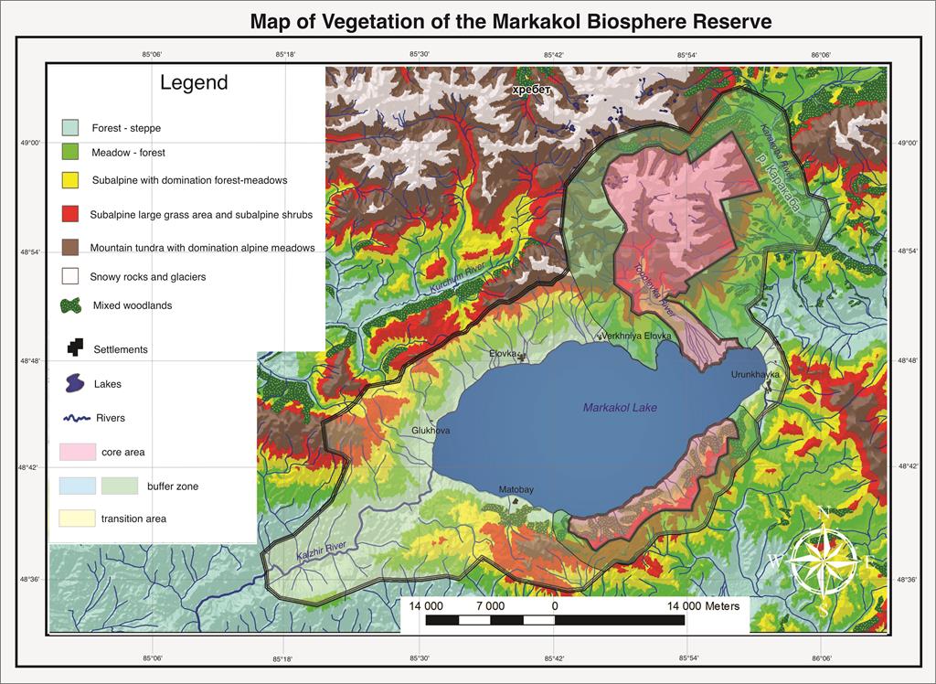
The territory of the Markakol biosphere Reserve belongs to the forest - meadow - steppe middle and high - mountain geobotanical region of the South Altai mountain and forest - meadow-steppe district. In this territory, five high-altitude vegetation zones are generally distinguished: forest-steppe, mountain-taiga, subalpine, alpine and nival.
The strip from the water edge of the lake to the lower border of forest phytocenoses at an altitude of 1449.5-1500 m above the sea level. the sea. It is formed on a flat lake-river plain, partially rising along the plumes on the lower part of the southern slopes, along the cones of the river outflow. Within the belt, 15 formations are identified, each of which consists of several plant associations.
Mountain-taiga belt. It occupies almost the entire territory of the southern mountain and forest area (the northern slope of the Azutau ridge) from the coastline to the heights of 1900 m. The main background is larch light coniferous forests, which occupy 61% of the entire forested area.
Within the mountain-taiga belt, 3 high-altitude bands are distinguished: I lower-birch-larch forests. From the water's edge to the upper border, Betula pendula (1500-1600 m) is widespread, the grass layer is mixed grass. II middle - larch and dark coniferous forests. Dark coniferous forests are indigenous, formed on the current territory of the reserve before the maximum glaciation. Currently, they have been preserved in small areas, are relatively environmentally friendly, and are often in a depressed state. Larix sibirica-edifier of young forest phytocenoses of the post-glacial period; in the area of the reserve, they are located on the southern border of the range.
The subalpine belt unites communities in the area of the upper border of the forest in the altitude range of 1800-1900-2000-2100 m above sea level. It includes meadow and subalpine forest communities. For the subalpine belt of the territory, the following 2 sub-belts can be allocated: I for the belt of subalpine meadows and II for the glacier sub-belt.
Conditions of sufficient moisture are characteristic for the I sub-belt of subalpine meadows, due to a much late melting snow cover, vapor condensation and significant precipitation in the summer period. They are characterized by a short vegetation period (the minimum for subalpine high-grass meadows): approximately with 1-10.VI by 20% due to rapid withering.
The formation of high-grass subalpine meadows is most pronounced in the northern section, in the lower part of the subalpine belt, alternating with high-grass larch trees, above-entering into a complex with park larch subalpine on the micro-slopes of the northern exposure. They are similar in the nature of vegetation to forest high-grass meadows, but they are characterized by a peculiar species composition and genesis: they are a primary formation associated with the upper border of the forest, while forest meadows are the result of fires and forest death, which makes it possible to attribute subalpine high - grass meadows to a separate formation. The communities are 2-tier: the I tier reaches a height of 100-150 cm of grass, the projective cover is 100%, the blackness is 6-8%. The composition of cereals is poor: Calamagrostis sp., Poa sibirica, Alopecurus alpinum. The moss cover is absent or poorly developed. The herbage contains 64% of the forest species represented in the first tier: Rhaponticum carthamoides, Saussurea frolowii, Trollius altaicus, Geranium albiflorum, Bupleurum longifoilium, Delphinium elatum, Aconitum septentrionale, Hedysarum austrosibiricum, Veratrum lobelianum; и 50% арктоальпийских видов, представленных во II ярусе: Dracocephalum grandiflorum, Phlomoides alpine, Aquilegia glandulosa, Ptarmica sp., Omalotheca norvegica.
II yernik girdle.
The community edifier is Betula rotundifolia. Under optimal conditions, it creates phytocenotically stable thickets of shrubs under the canopy of subalpine forest communities. On the border with the Alpine-tundra belt, it enters into synusion with tundra communities (complexes with fragments of alpine meadows, moss and lichen tundras). In the southern section, Betula rotundifolia communities are less common, Juniperus sibirica and J. pseudosabina dominate in the undergrowth of subalpine forest communities, which also form shrubby thickets on open slopes.
Alpine-tundra belt.
This is a complex complex of South Siberian alpine-type formations at absolute altitudes of 2000-2500 m above sea level, associated with the position of the snow line. There is an indistinct floral and phytocenotic boundary between tundra and alpine communities. The mountain tundra is characterized by specific conditions: peculiar relief forms - highly elevated plateaus, a sharply continental climate, the presence of permafrost thawing during the growing season in the area of the location of root systems. A large variety of communities is caused by a variety of mutual transitions from alpine to tundra. The sparsity of vegetation cover, the development of mosses and lichens is taken as the criterion for distinguishing grassy tundras from Alpine meadows. Often there are species that have fallen into the Alpine-tundra zone accidentally, in favorable environmental conditions from the lower mountain belts: Caltha palustris, Calamagrostis sp., Angelica deccurens.
Alpine nival belt extends at altitudes over 2800 m above sea level. There is no higher vegetation. Only some types of lichens are found on rocky outcrops.
Thus, the distribution of the vegetation cover of the reserve obeys the laws of vertical soil-plant zonality. In addition, there is a pronounced asymmetry of the vegetation cover of the slopes of the northern and southern expositions with the dominance of forest and meadow - steppe communities, respectively, which is due to the oroclimatic differentiation of the slopes and the appropriate complex of microclimatic, edaphic and other conditions. The slopes of the intermediate exposures are characterized by a great variety, for grassy communities-mosaic vegetation.
The floral diversity of the territory under discussion includes about 700 species from 75 families. Within the Markakol basin, especially on the territory of the Markakol Reserve, many rare and endangered plant species have been preserved, a number of which are listed in the Red Books of various ranks, lists of rare plants, etc., there are also endemic species of Altai and the Altai - Sayan mountain region.
The secondary nature of a number of plant formations of the reserve in the conditions of the reserve provides a unique material for long-term observations of the process of restoration of modified plant communities excluded from anthropogenic impact, which could be useful in the environmental expertise of nature management projects as an objective forecast of the duration in time and the course of the process of restoration of vegetation cover when economic intervention is stopped.
The modern fauna of the Southern Altai is characterized by a high biological diversity (375 species): 12 species of fish, 3 species of amphibians, 11 species of reptiles, 280 species of birds, 69 species of mammals. Of this number, 324 species (86.4%) are represented in the fauna of the Markakolsky Reserve, which indicates a high level of representativeness of this territory and its exceptional importance as a repository of the gene pool of animals, including rare and endangered ones.
It is enough to note that Markakol, being the largest body of water in Altai, is the richest in species diversity of waterfowl and near-water birds, and in terms of the number of some species of ducks nesting here (bolshoy krokhal, crested black, gogol, sviyaz, etc.) has no equal among the Kazakh and Altai lakes. The reservoir also plays an exceptional role as a place of molting and migration stops of migrating waterfowl and near-water birds.
Rare and endangered species of animals, listed in the Red Book of animal species live on the territory of the reserve. These are representatives of the avifauna: black stork, osprey, golden eagle, white-tailed eagle, peregrine falcon,gray crane, owl. At the same time, the lake populations of black stork (15 pairs) and osprey (10 pairs) are the largest on the territory of Kazakhstan, which significantly increases the conservation status of this territory. The Altai ular inhabiting the alpine and tundra watersheds of the north-eastern part of the Kurchum ridge is found here in the only Kazakh nature reserves. Among the mammals, the snow leopard and the stone marten are rare and endangered species.
In general, the Markakol Biosphere Reserve preserves a unique gene pool of endemic subspecies-the Markakol lenk, Markakol grayling, belonging to salmon-like fish, as well as subspecies of minnow and char. The spawning areas of lenka and grayling are concentrated in the 5 largest tributaries and the source of the Kalzhir River, which flows from the lake.
The unique composition of the ichthyofauna and the gene pool of the fish of the lake. Markakol was formed as a result of prolonged isolation, due to the existence of a geographical barrier in the middle course of the Kalzhir River. The absence of a protected area regime on this site threatens, in the case of geological developments, to disrupt the lake's ecosystem, up to its complete degradation.
Waterfalls located in the gorge of the Kalzhir River from the source of the lake to the Kyzylashchi tract prevent the penetration of river fish living in the area from these waterfalls to the waterfalls near the village of Prirechnoye.
For the conservation of biodiversity, two species are of great importance - lenok and grayling, whose river forms are not covered by the protected regime in Kazakhstan.
The areas of the reserve are the most important habitats of 18 species of valuable hunting and commercial animals: brown bear, fox, wolf, wolverine, sable, solongoy, ermine, steppe ferret, American mink, badger, river otter, lynx, elk, maral, roe deer, squirrel, gray marmot and white hare.
The source of the Kaldzhir plays a key role as a place of migration and feeding concentration of many waterfowl and near-water birds, especially river and diving ducks, waders, gulls and terns. The ice-free areas of the upper reaches of the Kaldzhir are the main wintering place for waterfowl (big krochal, gogol, crested blackbird, mallard), which also require special protection. In addition, the Kaldzhira Gorge is a place of permanent nesting of red-book species - black stork, golden eagle and eagle owl, the lower reaches of the Tikhushki, Zhirenka, Poplar and Glukhovaya rivers remain mainly the habitat of the gray crane, osprey and white-tailed eagle. Their complete conservation will preserve the unique populations of these rare species. Ecosystems of swamps, meadows, spruce forests, birch forests, poplars in the lower reaches of the Tikhushki, Zhirenka, Topolevka and Glukhovaya rivers, as well as petrophilic and mountain-steppe complexes of the Kaldzhira Gorge, which are protected, are of exceptional value for birds, mammals, amphibians and reptiles.
According to the system of categories of protected areas of the International Union for Conservation of Nature (IUCN), the Markakol Biosphere Reserve is included in the first category (1a)- "Strictly protected natural reserve - the surface of the earth and/or a section of the sea with unique or typical ecosystems, geological or physiological features and/or species suitable mainly for scientific research and/or environmental monitoring".
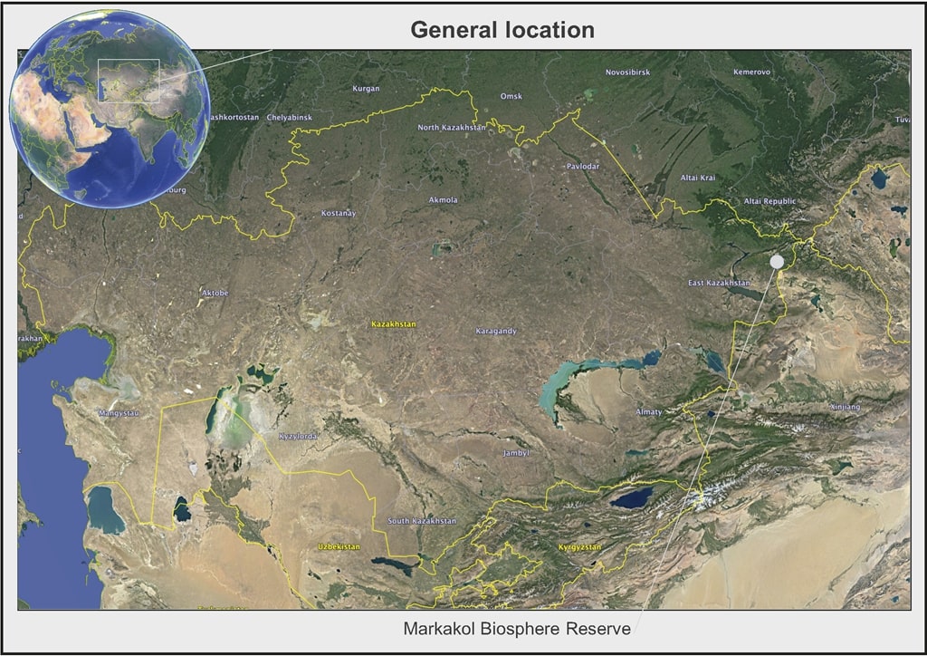
The biosphere reserve, the Markakol basin and the territories adjacent to it are located at a considerable distance from the district (the village of Kurchum-250 km) and from the regional center (the city of Ust-Kamenogorsk-500 km), which allows avoiding a high level of atmospheric pollution. The absence of large livestock farms within the basin has a positive effect on the purity of the lake's water and the rivers flowing into it, which stabilizes the state of the lake's aquatic flora. All of the above made it possible to preserve the phyto-diversity not only within the reserve, but also in the Markakol basin as a whole.
The unique geographical position of the East Kazakhstan region is that it is located in the depths of the largest continent of Eurasia, within its central part, on the border of the great plains – Western Siberia, Central Asia and Kazakhstan. The pole of the planet's continentality and the geographical center of Eurasia are located on the territory of the region. The variety of natural conditions and resources is favorable for its economic development. East Kazakhstan lies at the crossroads of the great waterway along the Irtysh and the Ob, is connected by the most important railway and automobile highways with neighboring regions of our republic, with states developed in economic and cultural relations.
Fisheries. In accordance with the order of the Chairman of the Committee of Forestry and Wildlife of the Ministry of Agriculture of the Republic of Kazakhstan "On approval of the Rules for the use of protected Areas by individuals" dated February 9, 2007, fishing is not allowed on the territory of the state nature reserve, with the exception of amateur fishing, allowed for the needs of the local population living in the protected zone of the state nature reserve, on specially designated areas in accordance with the procedure established by the authorized body in the field of specially protected natural territories. Since 1993, residents of coastal villages have been allowed to conduct amateur and sports fishing in limited areas of Lake Markakol, which together makes up about 5 % of the lake's water area. At this time, these are the following sites that have not yet been approved by the authorized body:
Plot No. 1. Is located directly in the north-eastern part of Lake Markakol, adjacent directly to the coast of the location of the settlement of the village of Urunhaika. The area is 250 hectares.
Plot No. 2. Is located in the southwestern part of Lake Markakol, adjacent directly to the coast of the location of the settlement of the village of Matobai. The area is 60 hectares.
Plot No. 3. Is located in the northern part of Lake Markakol, adjacent directly to the coast of the location of the settlement of the village of Karagaily-Bulak. The area is 40 hectares.
Plot No. 4. Is located in the northern part of Lake Markakol, adjacent directly to the coast of the location of the settlement of the village of Verkhnyaya Yelovka. The area is 20 hectares.
Artificial reproduction of fish is not performed on the territory of the Markakolsky Reserve.
The territory of the biosphere reserve is located in the Kurchum district of the East Kazakhstan region. The district was formed in 1927. The center of the district is located in the village of Kurchum. The main directions of the economy: agricultural production; forestry, timber processing. The district covers an area of 23.2 thousand km, which is 8.2% of the total area of the region. Agricultural lands make up 16.2% of the entire territory of the district, the lands of settlements-8.9%, the lands of the reserve and special land fund-72.0 %, other lands-1.8%.
The total population of the district as of 2019 is 23.3 thousand people. The district consists of 61 settlements, 12 rural districts. The population of the district continues to decrease despite the fact that 133 Oralmans families arrived here for permanent residence in 2007, and the total number of displaced families reached 412 or 1,900 people.Сокращение населения наблюдается во всех сельских округах. Compared to 1999, the year of the last census, the population has decreased by 3,657 people. Birth rates indicate that the demographic situation in the district as a whole is stabilizing, natural growth has increased. If in 2016 the natural population growth was 120 people, then in 2017 there were already 126-481 people were born, 355 died. But this does not apply to project villages, almost all rural districts have a negative growth balance.
The strong migration outflow of the population from the project villages continues, the population has decreased by 388 people in just one year, and migration within the region accounts for a large share. 20-30 families leave almost every village every year. Most of the population goes to the city of Ust-Kamenogorsk and the areas located in close proximity to the city of Ust-Kamenogorsk. Thus, the main source of population growth in the Kurshim district was a slight natural increase in the population and the influx of ethnic Kazakhs from China. Number of yards Maraldin rural district – 203, Terektн-1135 (Terekty 980, Akzhailau 97, Matabay 17, Moyyldy 23, Tentek 18), Akbulak-238, Toskain-332 (Toskain 142, Shanagaty 25, Bugumuyuz 30, Balyktybulak 24, Urunhaika 111).
Industry. In the Maraldin rural district on the Pokrovskoye plateau, work has resumed on a gold deposit, currently the Altyn Aytas mine provides 68 people with work. In the Terektinsky rural district in the village of Akzhailau, Markakol Ormany LLP works, which is mainly engaged in logging, provides firewood to budget organizations, there is a sawmill at the LLP. In total, the LLP employs 21 people. There are small processing enterprises in a number of large settlements.
Agricultural industry. The specialization of agricultural formations is sheep breeding with developed cattle breeding. In the total volume of gross agricultural output, the share of livestock products is 72 %. Breeds of sheep - mongrel, crossbreed, from fine-wooled to coarse-haired. In cattle breeding - mainly crossbreeds of both meat and dairy breeds, unproductive. In horse breeding, the main number of horses is mongrel. The main producer of livestock products is the population: in private farmsteads, which produces meat-90 %, milk-90 %, eggs-99.6 % and 77 % wool. There were no significant changes from 2013 to 2018 in the specialization of agricultural formations and private court farms on the project territory. The main industry of the population and peasant and farm enterprises remains the livestock industry, and the sown areas and their structure have practically not changed.
Crop production. The main areas of agricultural land are occupied by pastures, which makes up 50.6% of the total area, 45.1% is occupied by hay crops, and arable land occupies only 4.3%. The area of arable land is unevenly distributed due to the peculiarities of the relief and the location of the territory of rural districts: Terekty – 927 ha; Kalzhir-408 ha; Buranovsky-359 ha; Akbulak-29 ha; there are no sown areas at all in Toskain. The main reason for the decline in arable land is the sharply continental harsh climate, as well as unstable incomes from the production of crop products, the obsolescence of the machine-tractor fleet of peasant and farm farms, which led to a reduction in arable land, and an increase in the number of animals led to the expansion of areas under hayfields and pastures. The main directions of the economy of the population and agricultural enterprises are animal husbandry (sheep and horse breeding), and on arable lands are cultivated: spring wheat, barley, oats, buckwheat. In the structure of sown areas, wheat in 2012-2016 was 15.6%, and from 2012 to 2018 – 10.3 %, legumes and other crops occupied 23.4% and 21.8%, respectively%
Animal husbandry. By species, the largest number of animals over the past ten years has been occupied by sheep and goats. The main livestock of up to 90% of sheep and goats are concentrated in the farms of the population. In the dynamics of the last ten years, there has been an increase in the number of sheep and goats in all categories of farms on the project territory. The increase in the number of these animal species is associated with the traditions and breeding skills of the indigenous population, since the main population is Kazakhs, as well as with the simplicity of their maintenance in this region. Historical excursion the name of the lake Markakol from the legend from the word "mark" is a one-year-old lamb. The main reason for such a sharp increase in the number of animals is due to the change in the specialization of the population's farms, peasant and farm farms, in the direction of increasing the livestock industry and reducing the production of crop products.
Horses are kept by the population of all rural districts, as well as medium-sized and small peasant farms of the districts are engaged in breeding horses. However, the main livestock of up to 85 % is concentrated in the households of the population. The total number of horses in the Markakol section is 13,500. The number of horses over the past ten years, as well as the number of sheep and goats, cattle, increases annually. In the territory of rural districts of Markakol, the number of pigs, due to the reduction of acreage under grain crops, is decreasing, and in 2017 it amounted to only 100 heads. Domestic birds (chickens, geese, ducks, turkeys) are bred in private farmsteads by the population of rural districts of two districts. In recent years, their number in comparison with 2018 (52150) has increased from 18700 to 40600 units. All types of farm animals and birds available in the private sector, in agricultural enterprises are mongrel-crossbreeds of breeds imported to these areas in the 80s of the twentieth century. The main types of livestock and poultry products of the population are: meat (beef, horse meat, lamb, pork, goose, chicken, duck, turkey), cow's milk, mare's milk (kumis), chicken eggs, sheep wool, hides ( cattle, sheep, horses).
The work on environmental education in the reserve is carried out according to the plan of cultural and educational events, which is developed and approved by the director of the organization. The staff of the reserve has been participating in the international action "March of Parks"every year since 1998. For participation in this action in 2018, a diploma of the Forestry and Hunting Committee was received in the nomination "The best video about the action".
During the field season, excursions along the ecological trail and tourist routes are carried out. Lectures and talks are held all year round in the Nature Reserve Museum. The Urunkhayan School offers lectures and talks, elective classes, competitions and quizzes. Leaflets on environmental protection are issued. The campaign "Cleanliness", "Clean Coast"is held annually. Since 2005, the tradition of the school "Blue Patrol" has been resumed during the spawning of valuable fish species of Lake Markakol. The employees of the reserve constantly present environmental and educational materials in the district and regional press, take an active part in the filming of TV shows and documentaries about the reserve and the life of the Primarkakolya.
A positive example of the cultural and educational activities of the reserve can be considered the organization of a nature museum in the reserve, where exhibits and photographs of animals and plants representing the species diversity of the nature of the Markakol Nature Reserve are presented. The annual environmental campaign "March of Parks" is developed at the beginning of the year and approved at a meeting of the Scientific and Technical Council. The reserve traditionally organizes the environmental campaign "March of Parks".